Difference between revisions of "2012-09-01 55 37"
imported>Jiml m (Adjust result codes) |
imported>FippeBot m (Location) |
||
| (4 intermediate revisions by 2 users not shown) | |||
| Line 1: | Line 1: | ||
| − | |||
| − | |||
| − | |||
| − | |||
| − | |||
| − | |||
| − | |||
| − | |||
| − | |||
{{meetup graticule | {{meetup graticule | ||
| lat=55 | | lat=55 | ||
| Line 67: | Line 58: | ||
<!-- Add any achievement ribbons you earned below, or remove this section --> | <!-- Add any achievement ribbons you earned below, or remove this section --> | ||
| − | |||
| − | |||
| − | |||
| − | |||
| − | |||
| − | |||
| Line 78: | Line 63: | ||
[[Category:Expeditions with photos]] | [[Category:Expeditions with photos]] | ||
| − | |||
[[Category:Coordinates not reached]] | [[Category:Coordinates not reached]] | ||
| + | |||
[[Category:Not reached - No public access]] | [[Category:Not reached - No public access]] | ||
| + | {{location|RU|MOW}} | ||
Latest revision as of 05:54, 13 August 2019
| Sat 1 Sep 2012 in 55,37: 55.6186898, 37.4424766 geohashing.info google osm bing/os kml crox |
Location
A road near Khovanskoye Cemetery just off the Moscow city limits.
Participants
Plans
Actually it's 5 km from where vb lives, so he's going to just walk there. Walking distance seems to be around 8km. The weather forecast promises no rain.
Since it's Saturday, vb is going to show up there at 4:00pm.
Expedition
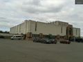
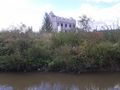
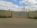
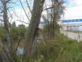
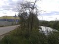
It was more like 4:30 than 4:00 when I got there. What seemed to be a lawn from satellite turned out to be a kind of moat with a kind of unfinished "castle" behind it. The hash was on the other side of the "moat". The closest I could get is 20-30 meters according to unstable GPS readings. The gate to the "castle" territory nearby was guarded.
Surrounding area, besides the cemetery, is filled with warehouses, garages, car dealerships, construction material shops. Thin overcrowded road, constant smell of exhaust and noise. The hill you can see on photos is not actually a hill but "recultivated" ex hard waste dump. So when in these surroundings I saw the "castle" it was one of those WTF O_o moments.
Tracklog
Photos
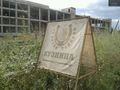
Blacksmith @55.6036,37.4650
Crematory @55.6094,37.4523
It's there @55.6185,37.4430
S
D
A
Sky
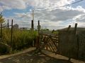
Gate


