Difference between revisions of "2012-09-09 11 77"
imported>Thevikas (→Participants) |
m |
||
| (11 intermediate revisions by 3 users not shown) | |||
| Line 1: | Line 1: | ||
| − | |||
| − | |||
| − | |||
| − | |||
| − | |||
| − | |||
| − | |||
| − | |||
| − | |||
| − | |||
{{meetup graticule | {{meetup graticule | ||
| lat=11 | | lat=11 | ||
| Line 15: | Line 5: | ||
}} | }} | ||
| − | |||
__NOTOC__ | __NOTOC__ | ||
== Location == | == Location == | ||
| Line 22: | Line 11: | ||
== Participants == | == Participants == | ||
| − | |||
| − | |||
* [[User:Thevikas|tjin]] 01:36, 10 September 2012 (EDT) | * [[User:Thevikas|tjin]] 01:36, 10 September 2012 (EDT) | ||
* Chhaya Yadav | * Chhaya Yadav | ||
| Line 29: | Line 16: | ||
== Plans == | == Plans == | ||
| − | + | The plan was made on Sunday noon. Was to be driven to using the car from Coimbatore city. We were to reach the point in day light. | |
== Expedition == | == Expedition == | ||
| − | + | We started using the chennai haighway towards Avinashi. We were watching google maps as well as openstreetmaps. Though google had more roads, only openstreetmap had indicated car roads. once following a google street we passed through one car wide road. Passed through many villages. So we reached the point by road that was 1.4km away from the point. | |
== Tracklog == | == Tracklog == | ||
| − | + | [http://www.everytrail.com/view_trip.php?trip_id=1762790 The trail] | |
== Photos == | == Photos == | ||
| − | |||
| − | |||
| − | |||
<gallery perrow="5"> | <gallery perrow="5"> | ||
| + | Image:2012-09-09 11 77 CoimbatoreIndia.jpg | Near Coimbatore, Tamil Nadu, India | ||
</gallery> | </gallery> | ||
== Achievements == | == Achievements == | ||
{{#vardefine:ribbonwidth|800px}} | {{#vardefine:ribbonwidth|800px}} | ||
| − | |||
| − | |||
| − | |||
| − | |||
| − | |||
| − | |||
| − | |||
| − | |||
| − | |||
| − | |||
| − | |||
[[Category:Expeditions]] | [[Category:Expeditions]] | ||
| − | |||
[[Category:Expeditions with photos]] | [[Category:Expeditions with photos]] | ||
| − | |||
| − | |||
| − | |||
| − | |||
| − | |||
| − | |||
| − | |||
| − | |||
| − | |||
[[Category:Coordinates not reached]] | [[Category:Coordinates not reached]] | ||
| − | + | [[Category:Not reached - Unknown]] | |
| − | + | {{location|IN|TN}} | |
| − | |||
| − | |||
| − | |||
| − | |||
| − | |||
| − | |||
| − | [[Category:Not reached - | ||
| − | |||
| − | |||
| − | |||
| − | |||
| − | |||
Latest revision as of 11:58, 21 April 2022
| Sun 9 Sep 2012 in 11,77: 11.1708079, 77.3592374 geohashing.info google osm bing/os kml crox |
Location
The hash is found near the village puluvapatti near Avinashi, Tamil Nadu. The closest major city is Coimbature, 55 km towards west and Chennai towards east. The location was within agriculture village land and approachable by mud roads only.
Participants
- tjin 01:36, 10 September 2012 (EDT)
- Chhaya Yadav
- Vinay Yadav
Plans
The plan was made on Sunday noon. Was to be driven to using the car from Coimbatore city. We were to reach the point in day light.
Expedition
We started using the chennai haighway towards Avinashi. We were watching google maps as well as openstreetmaps. Though google had more roads, only openstreetmap had indicated car roads. once following a google street we passed through one car wide road. Passed through many villages. So we reached the point by road that was 1.4km away from the point.
Tracklog
Photos
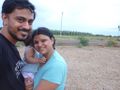
Near Coimbatore, Tamil Nadu, India
