Difference between revisions of "2012-09-27 32 -116"
From Geohashing
imported>LucasBrown ([live picture] Geohash Droid map at the hashpoint [http://www.openstreetmap.org/?lat=32.88194789&lon=-116.95342218&zoom=16&layers=B000FTF @32.8819,-116.9534]) |
imported>LucasBrown |
||
| Line 1: | Line 1: | ||
| − | |||
| − | |||
| − | |||
| − | |||
| − | |||
| − | |||
| − | |||
| − | |||
| − | |||
| − | |||
{{meetup graticule | {{meetup graticule | ||
| lat=32 | | lat=32 | ||
| Line 15: | Line 5: | ||
}} | }} | ||
| − | |||
__NOTOC__ | __NOTOC__ | ||
== Location == | == Location == | ||
| − | + | An empty lot in Lakeside | |
| + | |||
| + | == Notes == | ||
| + | Part 1 of a double hash (with [[2012-07-27 33 -117]]) | ||
== Participants == | == Participants == | ||
| − | + | [[User:LucasBrown|LucasBrown]] | |
| − | |||
| − | |||
| − | |||
| − | |||
| − | |||
| − | |||
| − | |||
| − | |||
| − | |||
| − | |||
== Photos == | == Photos == | ||
| − | |||
| − | |||
| − | |||
<gallery perrow="5"> | <gallery perrow="5"> | ||
| − | |||
Image:2012-09-27_32_-116_12-07-21-294.jpg | Geohash Droid details page at the hashpoint [http://www.openstreetmap.org/?lat=32.88195281&lon=-116.95342024&zoom=16&layers=B000FTF @32.8820,-116.9534] | Image:2012-09-27_32_-116_12-07-21-294.jpg | Geohash Droid details page at the hashpoint [http://www.openstreetmap.org/?lat=32.88195281&lon=-116.95342024&zoom=16&layers=B000FTF @32.8820,-116.9534] | ||
| − | |||
Image:2012-09-27_32_-116_12-08-13-611.jpg | Geohash Droid map at the hashpoint [http://www.openstreetmap.org/?lat=32.88194789&lon=-116.95342218&zoom=16&layers=B000FTF @32.8819,-116.9534] | Image:2012-09-27_32_-116_12-08-13-611.jpg | Geohash Droid map at the hashpoint [http://www.openstreetmap.org/?lat=32.88194789&lon=-116.95342218&zoom=16&layers=B000FTF @32.8819,-116.9534] | ||
</gallery> | </gallery> | ||
| Line 46: | Line 23: | ||
== Achievements == | == Achievements == | ||
{{#vardefine:ribbonwidth|800px}} | {{#vardefine:ribbonwidth|800px}} | ||
| − | + | {{Multihash2 | count = 2 | date = 2012-09-27 | name = LucasBrown}} | |
| − | |||
<!-- =============== USEFUL CATEGORIES FOLLOW ================ | <!-- =============== USEFUL CATEGORIES FOLLOW ================ | ||
Revision as of 18:42, 28 September 2012
| Thu 27 Sep 2012 in 32,-116: 32.8819631, -116.9534117 geohashing.info google osm bing/os kml crox |
Location
An empty lot in Lakeside
Notes
Part 1 of a double hash (with 2012-07-27 33 -117)
Participants
Photos
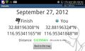
Geohash Droid details page at the hashpoint @32.8820,-116.9534
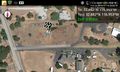
Geohash Droid map at the hashpoint @32.8819,-116.9534


Achievements
LucasBrown earned the Multihash Achievement
|