Difference between revisions of "2012-09-29 32 -116"
From Geohashing
imported>LucasBrown (→Plans) |
imported>LucasBrown (→Tracklog) |
||
| Line 25: | Line 25: | ||
== Expedition == | == Expedition == | ||
<!-- how it all turned out. your narrative goes here. --> | <!-- how it all turned out. your narrative goes here. --> | ||
| − | |||
| − | |||
| − | |||
== Photos == | == Photos == | ||
Revision as of 00:15, 30 September 2012
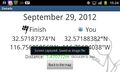
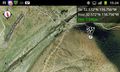
| Sat 29 Sep 2012 in 32,-116: 32.5718737, -116.7560506 geohashing.info google osm bing/os kml crox |
Location
Atop a ridge near the head of the Tiujana River, just north of the Mexican border
Participants
Expedition
Photos
Geohash Droid details page at the hashpoint
Geohash Droid map at the hashpoint


Achievements