Difference between revisions of "2012-10-05 26 -98"
From Geohashing
imported>Lightrider ([retro picture] This is as close as I can get. No trespassing for me today. The dirt road to get here is pretty terrible. [http://www.openstreetmap.org/?lat=26.33580000&lon=-98.14800000&zoom=16&layers=B000FTF @26.3358,-98.1480]) |
Lightrider (talk | contribs) (→Achievements) |
||
| (3 intermediate revisions by 3 users not shown) | |||
| Line 15: | Line 15: | ||
}} | }} | ||
| − | + | ||
__NOTOC__ | __NOTOC__ | ||
== Location == | == Location == | ||
| Line 21: | Line 21: | ||
== Participants == | == Participants == | ||
| − | + | ||
| − | + | * [[User:Lightrider|Lightrider]] | |
== Plans == | == Plans == | ||
<!-- what were the original plans --> | <!-- what were the original plans --> | ||
| + | |||
| + | Unknown | ||
== Expedition == | == Expedition == | ||
| Line 32: | Line 34: | ||
*This is the closest one for the past thirty days. Might check it out soon. -- [[User:Lightrider|Lightrider]] [http://www.openstreetmap.org/?lat=26.33352840&lon=-98.16518481&zoom=16&layers=B000FTF @26.3335,-98.1652] 17:51, 3 November 2012 (EDT) | *This is the closest one for the past thirty days. Might check it out soon. -- [[User:Lightrider|Lightrider]] [http://www.openstreetmap.org/?lat=26.33352840&lon=-98.16518481&zoom=16&layers=B000FTF @26.3335,-98.1652] 17:51, 3 November 2012 (EDT) | ||
| − | + | ||
| − | |||
== Photos == | == Photos == | ||
| − | + | ||
| − | |||
| − | |||
<gallery perrow="5"> | <gallery perrow="5"> | ||
| − | |||
Image:2012-10-05_26_-98_17-40-21-232.jpg | This is as close as I can get. No trespassing for me today. The dirt road to get here is pretty terrible. [http://www.openstreetmap.org/?lat=26.33580000&lon=-98.14800000&zoom=16&layers=B000FTF @26.3358,-98.1480] | Image:2012-10-05_26_-98_17-40-21-232.jpg | This is as close as I can get. No trespassing for me today. The dirt road to get here is pretty terrible. [http://www.openstreetmap.org/?lat=26.33580000&lon=-98.14800000&zoom=16&layers=B000FTF @26.3358,-98.1480] | ||
</gallery> | </gallery> | ||
| Line 48: | Line 46: | ||
<!-- Add any achievement ribbons you earned below, or remove this section --> | <!-- Add any achievement ribbons you earned below, or remove this section --> | ||
| + | {{No trespassing |latitude=26 |longitude=-98 |date=2012-10-05 |image=2012-10-05_26_-98_17-40-21-232.jpg |name= [[User:Lightrider|Lightrider]] ([[User talk:Lightrider|talk]]) |distance= }} | ||
| − | |||
| − | |||
| − | |||
| − | + | [[Category:Expeditions]] | |
| − | |||
| − | [[Category: | ||
| − | |||
| − | |||
| − | |||
| − | |||
[[Category:Expeditions with photos]] | [[Category:Expeditions with photos]] | ||
| − | |||
| − | |||
| − | |||
| − | |||
| − | |||
| − | |||
| − | |||
| − | |||
| − | |||
[[Category:Coordinates not reached]] | [[Category:Coordinates not reached]] | ||
| − | |||
| − | |||
| − | |||
| − | |||
| − | |||
[[Category:Not reached - No public access]] | [[Category:Not reached - No public access]] | ||
| − | + | {{location|US|TX|HG}} | |
| − | |||
| − | |||
| − | |||
| − | |||
| − | |||
| − | |||
| − | |||
Latest revision as of 11:57, 10 February 2023
| Fri 5 Oct 2012 in 26,-98: 26.3384724, -98.0969051 geohashing.info google osm bing/os kml crox |
Location
Participants
Plans
Unknown
Expedition
- This is the closest one for the past thirty days. Might check it out soon. -- Lightrider @26.3335,-98.1652 17:51, 3 November 2012 (EDT)
Photos
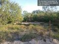
This is as close as I can get. No trespassing for me today. The dirt road to get here is pretty terrible. @26.3358,-98.1480

Achievements
Lightrider (talk) earned the No trespassing consolation prize
|