Difference between revisions of "2012-10-08 47 -122"
imported>Nokoose (→Location) |
imported>FippeBot m (Location) |
||
| (5 intermediate revisions by 2 users not shown) | |||
| Line 19: | Line 19: | ||
== Location == | == Location == | ||
<!-- where you've surveyed the hash to be --> | <!-- where you've surveyed the hash to be --> | ||
| − | Hash location was on the grounds of Joint Base Lewis McChord, not accessible to the public | + | Hash location was on the grounds of Joint Base Lewis McChord, not accessible to the public, Failed to reach actual point. |
== Participants == | == Participants == | ||
| Line 27: | Line 27: | ||
== Plans == | == Plans == | ||
<!-- what were the original plans --> | <!-- what were the original plans --> | ||
| − | The actual | + | The actual point is not reachable due to it being part of a military installation, But I plan on getting as close as legally possible. |
== Expedition == | == Expedition == | ||
| Line 41: | Line 41: | ||
--> | --> | ||
<gallery perrow="5"> | <gallery perrow="5"> | ||
| + | Image:2010-10-08 hashpoint map.jpg| Map view of the hashpoint from Google Maps | ||
| + | Image:2010-10-08 hashpoint.jpg| Actual Location of Geo Hash from Google Maps | ||
| + | Image:10-08-2012.jpg| Quick pic from the side of the road nearest the actual Hash. | ||
</gallery> | </gallery> | ||
| Line 47: | Line 50: | ||
<!-- Add any achievement ribbons you earned below, or remove this section --> | <!-- Add any achievement ribbons you earned below, or remove this section --> | ||
| − | |||
| − | |||
| − | |||
| − | |||
| − | |||
| − | |||
| − | |||
| − | |||
| − | |||
| − | |||
| − | |||
[[Category:Expeditions]] | [[Category:Expeditions]] | ||
| − | |||
[[Category:Expeditions with photos]] | [[Category:Expeditions with photos]] | ||
| − | |||
| − | |||
| − | |||
| − | |||
| − | |||
| − | |||
| − | |||
| − | |||
| − | |||
[[Category:Coordinates not reached]] | [[Category:Coordinates not reached]] | ||
| − | |||
| − | |||
| − | |||
| − | |||
| − | |||
[[Category:Not reached - No public access]] | [[Category:Not reached - No public access]] | ||
| − | + | {{location|US|WA|PI}} | |
| − | |||
| − | |||
| − | |||
| − | |||
| − | |||
| − | |||
| − | |||
Latest revision as of 06:27, 13 August 2019

| Mon 8 Oct 2012 in 47,-122: 47.0565762, -122.4743572 geohashing.info google osm bing/os kml crox |
Location
Hash location was on the grounds of Joint Base Lewis McChord, not accessible to the public, Failed to reach actual point.
Participants
Nokoose
Plans
The actual point is not reachable due to it being part of a military installation, But I plan on getting as close as legally possible.
Expedition
This being my first actual geohash attempt, I went off knowing I would fail to reach the actual coordinates. Rode out from Lakewood, hoping to get as close as possible to the actual hash knowing I couldn't actually reach it legally. But any excuse for a ride in good weather is good enough. Went to the closest safe pull off point, parked the bike snapped a quick pic at around 4:15 pm, rode off again. Nothing to serious, just an easy goal for me as my first attempt.
Tracklog
Photos
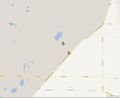
Map view of the hashpoint from Google Maps
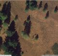
Actual Location of Geo Hash from Google Maps
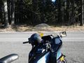
Quick pic from the side of the road nearest the actual Hash.

