Difference between revisions of "2012-10-17 54 -2"
From Geohashing
imported>Angel (As on Sunday, I think I'll have to submit "No access" - farmer appears to have blocked off public footpath, and I hear dog(s) in the yard [http://www.openstreetmap.org/?lat=54.11420000&lon=-2.63239000&zoom=16&layers=B000FTF @54.1142,-2.6324]) |
imported>FippeBot m (Location) |
||
| (3 intermediate revisions by 2 users not shown) | |||
| Line 47: | Line 47: | ||
{{#vardefine:ribbonwidth|800px}} | {{#vardefine:ribbonwidth|800px}} | ||
<!-- Add any achievement ribbons you earned below, or remove this section --> | <!-- Add any achievement ribbons you earned below, or remove this section --> | ||
| − | + | {{No trespassing |latitude=54 |longitude= -2|date= 2012-10-17|name= [[User:Angel|Angel]]|distance=99%}} | |
<!-- =============== USEFUL CATEGORIES FOLLOW ================ | <!-- =============== USEFUL CATEGORIES FOLLOW ================ | ||
Delete the next line ONLY if you have chosen the appropriate categories below. If you are unsure, don't worry. People will read your report and help you with the classification. --> | Delete the next line ONLY if you have chosen the appropriate categories below. If you are unsure, don't worry. People will read your report and help you with the classification. --> | ||
| − | |||
| − | |||
| − | |||
| − | |||
| − | |||
[[Category:Expeditions]] | [[Category:Expeditions]] | ||
| − | |||
[[Category:Expeditions with photos]] | [[Category:Expeditions with photos]] | ||
| − | |||
| − | |||
| − | |||
| − | |||
| − | |||
| − | |||
| − | |||
| − | |||
[[Category:Coordinates not reached]] | [[Category:Coordinates not reached]] | ||
| − | |||
| − | |||
| − | |||
| − | |||
| − | |||
[[Category:Not reached - No public access]] | [[Category:Not reached - No public access]] | ||
| − | + | {{location|GB|ENG|LAN}} | |
| − | |||
| − | |||
| − | |||
| − | |||
| − | |||
| − | |||
| − | |||
Latest revision as of 06:33, 13 August 2019
| Wed 17 Oct 2012 in 54,-2: 54.0912733, -2.5897449 geohashing.info google osm bing/os kml crox |
Location
Between Halton and Wray, 9 miles from the centre of Lancaster.
Participants
Plans
Google Maps says this should be accessible on foot, 12 miles from home. I planned to set off early, but I only managed to get up at 10. Still, now (at the time of posting) its nearly noon, and I've already covered nearly 5 miles and am coming up to the Crook o'Lune picnic site, which is probably around 5 miles from the hashpoint. I'm sure I can make it in time, heading up the Lune cyclepath (National Cycle Route 69) as far as Bull Beck then turning onto the road.
Expedition
Tracklog
Photos
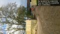
As on Sunday, I think I'll have to submit "No access" - farmer appears to have blocked off public footpath, and I hear dog(s) in the yard @54.1142,-2.6324

Achievements
Angel earned the No trespassing consolation prize
|