Difference between revisions of "2012-10-25 33 -117"
From Geohashing
imported>Mathgeek (→Participants) |
imported>FippeBot m (Location) |
||
| (One intermediate revision by one other user not shown) | |||
| Line 1: | Line 1: | ||
| − | |||
<!-- If you did not specify these parameters in the template, please substitute appropriate values for IMAGE, LAT, LON, and DATE (YYYY-MM-DD format) | <!-- If you did not specify these parameters in the template, please substitute appropriate values for IMAGE, LAT, LON, and DATE (YYYY-MM-DD format) | ||
| Line 15: | Line 14: | ||
}} | }} | ||
| − | + | ||
__NOTOC__ | __NOTOC__ | ||
== Location == | == Location == | ||
| − | + | ||
| + | Somewhere in Southern California | ||
== Participants == | == Participants == | ||
| − | + | * [[User:Mathgeek|Mathgeek]] | |
| − | |||
| − | [[User:Mathgeek|Mathgeek]] | ||
== Plans == | == Plans == | ||
| Line 33: | Line 31: | ||
*Fences, caution tape, barbed wire and signs today. No luck. -- [[User:Mathgeek|Mathgeek]] [http://www.openstreetmap.org/?lat=33.02286371&lon=-117.15248116&zoom=16&layers=B000FTF @33.0229,-117.1525] 11:26, 25 October 2012 (PDT) | *Fences, caution tape, barbed wire and signs today. No luck. -- [[User:Mathgeek|Mathgeek]] [http://www.openstreetmap.org/?lat=33.02286371&lon=-117.15248116&zoom=16&layers=B000FTF @33.0229,-117.1525] 11:26, 25 October 2012 (PDT) | ||
| + | |||
| + | |||
== Tracklog == | == Tracklog == | ||
<!-- if your GPS device keeps a log, you may post a link here --> | <!-- if your GPS device keeps a log, you may post a link here --> | ||
== Photos == | == Photos == | ||
| − | + | ||
| − | |||
| − | |||
<gallery perrow="5"> | <gallery perrow="5"> | ||
| − | |||
Image:2012-10-25_33_-117_11-27-10-975.jpg | One of several impediments. [http://www.openstreetmap.org/?lat=33.02273384&lon=-117.15244565&zoom=16&layers=B000FTF @33.0227,-117.1524] | Image:2012-10-25_33_-117_11-27-10-975.jpg | One of several impediments. [http://www.openstreetmap.org/?lat=33.02273384&lon=-117.15244565&zoom=16&layers=B000FTF @33.0227,-117.1524] | ||
</gallery> | </gallery> | ||
| Line 47: | Line 44: | ||
== Achievements == | == Achievements == | ||
{{#vardefine:ribbonwidth|800px}} | {{#vardefine:ribbonwidth|800px}} | ||
| − | + | ||
{{No trespassing | latitude = 33 | longitude = -117 | date = 2012-10-25 | name = Mathgeek | image = 2012-10-25_33_-117_11-27-10-975.jpg | distance = 665 ft}} | {{No trespassing | latitude = 33 | longitude = -117 | date = 2012-10-25 | name = Mathgeek | image = 2012-10-25_33_-117_11-27-10-975.jpg | distance = 665 ft}} | ||
| − | |||
| − | |||
| − | |||
| − | + | [[Category:Expeditions]] | |
| − | |||
| − | [[Category: | ||
| − | |||
| − | |||
| − | |||
| − | |||
[[Category:Expeditions with photos]] | [[Category:Expeditions with photos]] | ||
| − | + | [[Category:Coordinates not reached]] | |
| − | |||
| − | |||
| − | |||
| − | |||
| − | [[Category:Coordinates reached]] | ||
| − | |||
| − | |||
| − | |||
| − | |||
| − | |||
| − | |||
| − | |||
| − | |||
[[Category:Not reached - No public access]] | [[Category:Not reached - No public access]] | ||
| − | + | {{location|US|CA|SD}} | |
| − | |||
| − | |||
| − | |||
| − | |||
| − | |||
| − | |||
| − | |||
Latest revision as of 06:39, 13 August 2019
| Thu 25 Oct 2012 in 33,-117: 33.0243729, -117.1514927 geohashing.info google osm bing/os kml crox |
Location
Somewhere in Southern California
Participants
Plans
Expedition
- Fences, caution tape, barbed wire and signs today. No luck. -- Mathgeek @33.0229,-117.1525 11:26, 25 October 2012 (PDT)
Tracklog
Photos
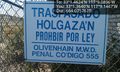
One of several impediments. @33.0227,-117.1524

Achievements
Mathgeek earned the No trespassing consolation prize
|