Difference between revisions of "2012-10-31 -35 149"
imported>1PE |
imported>FippeBot m (Location) |
||
| (2 intermediate revisions by one other user not shown) | |||
| Line 1: | Line 1: | ||
| − | + | [[Image:{{{image|2012-10-31 -35 149 view.JPG}}}|thumb|left]] | |
| − | |||
| − | |||
| − | |||
| − | |||
| − | |||
| − | |||
| − | |||
{{meetup graticule | {{meetup graticule | ||
| lat=-35 | | lat=-35 | ||
| Line 29: | Line 22: | ||
===[[User:1PE|1PE]]=== | ===[[User:1PE|1PE]]=== | ||
A sign at the entrance road to the gaol complex, at the corner of Morisset Road with Old Wells Station Road, proclaims "No Unauthorised Entry". Accordingly, I took pictures from there and at several points along Old Wells Station Road looking along Morisset Road towards the hash site. I was able to identify a prominent tree near the hash point, and will mark it on the images. A secondary road, parallel to Morisset Road and along the front of Bimberi, turns out to be a "right of way" and horse track, with a horse-safe stile on Old Wells Station Road. This road is beside the Canberra agricultural show grounds (Exhibition Park In Canberra -- EPIC) that is in turn over the road from the Canberra Racecourse. | A sign at the entrance road to the gaol complex, at the corner of Morisset Road with Old Wells Station Road, proclaims "No Unauthorised Entry". Accordingly, I took pictures from there and at several points along Old Wells Station Road looking along Morisset Road towards the hash site. I was able to identify a prominent tree near the hash point, and will mark it on the images. A secondary road, parallel to Morisset Road and along the front of Bimberi, turns out to be a "right of way" and horse track, with a horse-safe stile on Old Wells Station Road. This road is beside the Canberra agricultural show grounds (Exhibition Park In Canberra -- EPIC) that is in turn over the road from the Canberra Racecourse. | ||
| + | |||
| + | On the drive back to work, while passing the Australian War Memorial, I saw a commemoration of the 95th anniversary of the [http://en.wikipedia.org/wiki/Battle_of_Beersheba_(1917) Battle of Beersheba], with a 'troop' of horses with their riders dressed in World War 1 style uniforms proceeding along Anzac Parade. Look out for the pictures on Wikipedia. | ||
== Tracklog == | == Tracklog == | ||
| Line 38: | Line 33: | ||
--> | --> | ||
<gallery perrow="5"> | <gallery perrow="5"> | ||
| + | image:2012-10-31 -35 149 sign.JPG|No! Just, NO! | ||
| + | image:2012-10-31 -35 149 horse-gate.JPG|Horse gate | ||
| + | image:2012-10-31 -35 149 view.JPG|I can gaze, at least. | ||
| + | |||
</gallery> | </gallery> | ||
| Line 49: | Line 48: | ||
[[Category:Coordinates not reached]] | [[Category:Coordinates not reached]] | ||
[[Category:Not reached - No public access]] | [[Category:Not reached - No public access]] | ||
| − | |||
| − | |||
| − | |||
| − | |||
| − | |||
| − | |||
| − | |||
[[Category:Expeditions with photos]] | [[Category:Expeditions with photos]] | ||
| − | + | {{location|AU|ACT}} | |
| − | |||
| − | |||
Latest revision as of 06:44, 13 August 2019

| Wed 31 Oct 2012 in -35,149: -35.2209008, 149.1608167 geohashing.info google osm bing/os kml crox |
Location
In a field immediately to the east of the Bimberi Youth Justice Centre (gaol for young people under 18 years), near the Federal Highway, at the suburb of Mitchell, Australian Capital Territory.
Participants
- 1PE - around 12.45pm
Plans
1PE
Lunchtime excursion, parking on the road not too near Bimberi so as to not agitate the guards too much....
Expedition
1PE
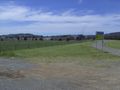
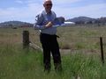
A sign at the entrance road to the gaol complex, at the corner of Morisset Road with Old Wells Station Road, proclaims "No Unauthorised Entry". Accordingly, I took pictures from there and at several points along Old Wells Station Road looking along Morisset Road towards the hash site. I was able to identify a prominent tree near the hash point, and will mark it on the images. A secondary road, parallel to Morisset Road and along the front of Bimberi, turns out to be a "right of way" and horse track, with a horse-safe stile on Old Wells Station Road. This road is beside the Canberra agricultural show grounds (Exhibition Park In Canberra -- EPIC) that is in turn over the road from the Canberra Racecourse.
On the drive back to work, while passing the Australian War Memorial, I saw a commemoration of the 95th anniversary of the Battle of Beersheba, with a 'troop' of horses with their riders dressed in World War 1 style uniforms proceeding along Anzac Parade. Look out for the pictures on Wikipedia.
Tracklog
Photos
No! Just, NO!
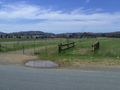
Horse gate
I can gaze, at least.


Achievements
- Potential for Police Geohash (with the prison guards).