Difference between revisions of "2012-10-31 32 -116"
From Geohashing
imported>LucasBrown ([live picture] Geohash droid details page at the hashpoint [http://www.openstreetmap.org/?lat=32.86748395&lon=-116.83858922&zoom=16&layers=B000FTF @32.8675,-116.8386]) |
imported>LucasBrown ([live picture] Sign posted near the hashpoint [http://www.openstreetmap.org/?lat=32.86785827&lon=-116.83797449&zoom=16&layers=B000FTF @32.8679,-116.8380]) |
||
| Line 42: | Line 42: | ||
Image:2012-10-31_32_-116_16-47-19-459.jpg | Geohash droid details page at the hashpoint [http://www.openstreetmap.org/?lat=32.86748395&lon=-116.83858922&zoom=16&layers=B000FTF @32.8675,-116.8386] | Image:2012-10-31_32_-116_16-47-19-459.jpg | Geohash droid details page at the hashpoint [http://www.openstreetmap.org/?lat=32.86748395&lon=-116.83858922&zoom=16&layers=B000FTF @32.8675,-116.8386] | ||
| + | |||
| + | Image:2012-10-31_32_-116_16-54-57-393.jpg | Sign posted near the hashpoint [http://www.openstreetmap.org/?lat=32.86785827&lon=-116.83797449&zoom=16&layers=B000FTF @32.8679,-116.8380] | ||
</gallery> | </gallery> | ||
Revision as of 23:55, 31 October 2012
| Wed 31 Oct 2012 in 32,-116: 32.8674821, -116.8385854 geohashing.info google osm bing/os kml crox |
Location
Participants
Plans
Expedition
Tracklog
Photos
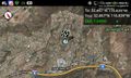
Geohash droid map at the hashpoint @32.8675,-116.8386
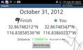
Geohash droid details page at the hashpoint @32.8675,-116.8386

Sign posted near the hashpoint @32.8679,-116.8380


Achievements