2012-11-10 53 -1
Contents
Location
53.679412°, -1.418292°
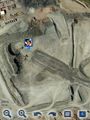
What appears on Google Maps as a quarry, but is now just a field
Participants
The Expedition
Jason was unavailable, so I dragged along my friend Becky after she had come over for Mexican on Friday night. We set off about 23:30 (Friday) to get to the geohash after midnight (Saturday). I always check Google Maps to see if the geohash looks accessible, this one looked to be in the middle of a quarry, but we couldn't see any gates or blocked entry, and considering this would be in the middle of the night, we hoped to be able just to walk in. The drive over was pretty uneventful, but once we got there the access road we saw on Google appeared to no longer exist, and after driving around, neither did the quarry! On driving along the bottom road however we found a public footpath to access the field that has replaced the old quarry, and after about a 15 minute walk we arrived at the location. One slight downfall is that we are both Blackberry users, so our end location is a screenshot from Google Maps, and although we couldn't get an accurate reading of how close we got, we're confident that we hit the spot. Walking back we decided to take a bit of a short cut across the field and got a little bit stuck in a ditch, but we persevered, made it back to the car, Becky wee'd in a bush, and we set of home via Krispy Kreme for a celebratory doughnut.
Photos
Screenshot


Screenshot


Screenshot
