Difference between revisions of "2012-11-20 -35 149"
imported>1PE |
m |
||
| (12 intermediate revisions by 3 users not shown) | |||
| Line 1: | Line 1: | ||
| − | |||
| − | |||
| − | |||
| − | |||
| − | |||
| − | |||
| − | |||
| − | |||
| − | |||
{{meetup graticule | {{meetup graticule | ||
| lat=-35 | | lat=-35 | ||
| Line 18: | Line 9: | ||
== Location == | == Location == | ||
===[[User:1PE|1PE]]=== | ===[[User:1PE|1PE]]=== | ||
| − | * Where-ever it is, I also have the option (on the 'anti-node' or 'half' of [[Geohashing | + | * Where-ever it is, I also have the option (on the 'anti-node' or 'half' of [[Geohashing Day]]) of halving the decimal coordinates and seeing whether that is more interesting/accessible. |
| + | ** REAL Location: -35.504137°, 149.305305° In scrub/bush on the eastern side of Googong Dam and its feeder river -- ''inaccessible in a practical sense''. | ||
| + | ** '''HALF' Location'': -35.252069°, 149.152653° In the open ground of the back yard of a house, on Majura Avenue, a major suburban arterial road in the suburb of Ainslie in north Canberra -- ''accessible!'' | ||
== Participants == | == Participants == | ||
| − | + | * [[User:1PE|1PE]] | |
| − | |||
== Plans == | == Plans == | ||
| − | * | + | ===[[User:1PE|1PE]]=== |
| + | * A lunchtime drive in the suburbs. I will respect the rights of the owner, but expect that I can get a picture down the side of the house if I can not get access directly. | ||
== Expedition == | == Expedition == | ||
| − | + | ===[[User:1PE|1PE]]=== | |
| + | The house is a a detached dwelling on a normal "quarter acre" house block. It is white-painted stucco with a "rancho" (Spanish) styling, and a side fence, that blocks all access to the back yard where the half-geohash is. It has extensive trees at the front, shading the verandah from prying eyes of people walking and driving along the busy road. On the verandah -- about 10m from the hash point -- I rang the door bell, and knocked on the second front door, but no-one came out. | ||
| + | |||
| + | I took several pictures, including one through a knot-hole in the side fence showing some details of the back yard. I chose to not enter the yard of the adjacent house, being renovated, although that would have allowed me to take a picture of the hash point from over the side fence. | ||
| + | |||
| + | ====The Flip==== | ||
| + | Just before leaving for the hash, I realised that "anti-node" was another way of saying "flip-side", and that this was the flip side of Mouse Over Day. So, ''I took along a computer mouse and held it flip-side up in the pictures''. | ||
== Tracklog == | == Tracklog == | ||
| Line 38: | Line 37: | ||
--> | --> | ||
<gallery perrow="5"> | <gallery perrow="5"> | ||
| + | File:2012-11-20_-35_149_front.jpeg| Rancho style. | ||
| + | File:2012-11-20_-35_149_back.jpeg|K-not getting a peek into the back yard hash. | ||
</gallery> | </gallery> | ||
| Line 46: | Line 47: | ||
| − | |||
| − | |||
| − | |||
| − | |||
| − | |||
| − | |||
[[Category:Expeditions]] | [[Category:Expeditions]] | ||
| − | |||
[[Category:Expeditions with photos]] | [[Category:Expeditions with photos]] | ||
| − | [[Category: | + | [[Category:Coordinates not reached]] |
[[Category:Expedition without GPS]] | [[Category:Expedition without GPS]] | ||
| − | |||
| − | |||
| − | |||
| − | |||
| − | |||
| − | |||
| − | |||
| − | |||
| − | |||
| − | |||
| − | |||
| − | |||
| − | |||
[[Category:Not reached - No public access]] | [[Category:Not reached - No public access]] | ||
| − | + | {{location|AU|NSW|QB}} | |
| − | |||
| − | |||
| − | |||
| − | |||
| − | |||
| − | |||
| − | |||
Latest revision as of 09:33, 16 March 2022
| Tue 20 Nov 2012 in -35,149: -35.5041369, 149.3053059 geohashing.info google osm bing/os kml crox |
Location
1PE
- Where-ever it is, I also have the option (on the 'anti-node' or 'half' of Geohashing Day) of halving the decimal coordinates and seeing whether that is more interesting/accessible.
- REAL Location: -35.504137°, 149.305305° In scrub/bush on the eastern side of Googong Dam and its feeder river -- inaccessible in a practical sense.
- 'HALF' Location: -35.252069°, 149.152653° In the open ground of the back yard of a house, on Majura Avenue, a major suburban arterial road in the suburb of Ainslie in north Canberra -- accessible!
Participants
Plans
1PE
- A lunchtime drive in the suburbs. I will respect the rights of the owner, but expect that I can get a picture down the side of the house if I can not get access directly.
Expedition
1PE
The house is a a detached dwelling on a normal "quarter acre" house block. It is white-painted stucco with a "rancho" (Spanish) styling, and a side fence, that blocks all access to the back yard where the half-geohash is. It has extensive trees at the front, shading the verandah from prying eyes of people walking and driving along the busy road. On the verandah -- about 10m from the hash point -- I rang the door bell, and knocked on the second front door, but no-one came out.
I took several pictures, including one through a knot-hole in the side fence showing some details of the back yard. I chose to not enter the yard of the adjacent house, being renovated, although that would have allowed me to take a picture of the hash point from over the side fence.
The Flip
Just before leaving for the hash, I realised that "anti-node" was another way of saying "flip-side", and that this was the flip side of Mouse Over Day. So, I took along a computer mouse and held it flip-side up in the pictures.
Tracklog
Photos
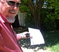
Rancho style.
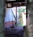
K-not getting a peek into the back yard hash.


Achievements
- Geohashing Anti-Node Day Achievement