Difference between revisions of "2012-11-28 61 23"
From Geohashing
imported>Teukkam |
imported>Teukkam ([live picture] Proof of frozen hash [http://www.openstreetmap.org/?lat=61.42354039&lon=23.87558866&zoom=16&layers=B000FTF @61.4235,23.8756]) |
||
| Line 42: | Line 42: | ||
--> | --> | ||
<gallery perrow="5"> | <gallery perrow="5"> | ||
| + | |||
| + | Image:2012-11-28_61_23_08-34-57-378.jpg | Proof of frozen hash [http://www.openstreetmap.org/?lat=61.42354039&lon=23.87558866&zoom=16&layers=B000FTF @61.4235,23.8756] | ||
</gallery> | </gallery> | ||
Revision as of 06:35, 28 November 2012
| Wed 28 Nov 2012 in 61,23: 61.4212409, 23.8777990 geohashing.info google osm bing/os kml crox |
Location
In Southern Hervanta on the side of Lempäälä, south of Lake Hervantajärvi and less than 1 km southwest from the Tampere-Lempäälä-Kangasala tri-municipal border point. The hash appears to be on the edge of a powerline clearing, just some 250 m off road. There's a large swamp called Pehkusuo nearby, but it looks like it might be possible to get to the hash with dry feet.
Participants
- TeukkaM plans to have a stab at this first thing in the morning.
Plans
The plan is to find a parking spot along Iso-Hervannantie, then find a suitable place to enter the forest.
Expedition
- Can't miss a hash this close to home. -- TeukkaM @61.4481,23.8341 07:04, 28 November 2012 (EET)
Tracklog
Photos
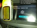
Proof of frozen hash @61.4235,23.8756

Achievements