2012-11-28 61 23
From Geohashing
Revision as of 06:54, 28 November 2012 by imported>Teukkam ([live] Punched through the forest to the clearing. The sun is not quite up yet.)
| Wed 28 Nov 2012 in 61,23: 61.4212409, 23.8777990 geohashing.info google osm bing/os kml crox |
Location
In Southern Hervanta on the side of Lempäälä, south of Lake Hervantajärvi and less than 1 km southwest from the Tampere-Lempäälä-Kangasala tri-municipal border point. The hash appears to be on the edge of a powerline clearing, just some 250 m off road. There's a large swamp called Pehkusuo nearby, but it looks like it might be possible to get to the hash with dry feet.
Participants
- TeukkaM plans to have a stab at this first thing in the morning.
Plans
The plan is to find a parking spot along Iso-Hervannantie, then find a suitable place to enter the forest.
Expedition
- Can't miss a hash this close to home. -- TeukkaM @61.4481,23.8341 07:04, 28 November 2012 (EET)
- Parked car here. Encountered a smuggle with a dog. Found out I had misconverted the coordinates for my eTrex so I had to reenter them. -- TeukkaM @61.4236,23.8756 08:46, 28 November 2012 (EET)
- Punched through the forest to the clearing. The sun is not quite up yet. -- TeukkaM @61.4219,23.8762 08:53, 28 November 2012 (EET)
Tracklog
Photos
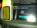
Proof of frozen hash @61.4235,23.8756

Achievements