Difference between revisions of "2013-01-12 40 -86"
imported>StatMan22 (Created page with "{{subst:Expedition |40 = latitude of graticule |-86 = longitude of graticule |2013-01-12 = date of expedition, in YYYY-MM-DD format }}") |
imported>FippeBot m (Location) |
||
| (8 intermediate revisions by 3 users not shown) | |||
| Line 1: | Line 1: | ||
| − | |||
<!-- If you did not specify these parameters in the template, please substitute appropriate values for IMAGE, LAT, LON, and DATE (YYYY-MM-DD format) | <!-- If you did not specify these parameters in the template, please substitute appropriate values for IMAGE, LAT, LON, and DATE (YYYY-MM-DD format) | ||
| − | |||
| − | |||
Remove this section if you don't want an image at the top (left) of your report. You should remove the "Image:" or "File:" | Remove this section if you don't want an image at the top (left) of your report. You should remove the "Image:" or "File:" | ||
| Line 10: | Line 7: | ||
--> | --> | ||
{{meetup graticule | {{meetup graticule | ||
| − | | lat= | + | | lat=40 |
| − | | lon= | + | | lon=-86 |
| − | | date= | + | | date=2013-01-12 |
}} | }} | ||
| Line 19: | Line 16: | ||
== Location == | == Location == | ||
<!-- where you've surveyed the hash to be --> | <!-- where you've surveyed the hash to be --> | ||
| + | |||
| + | It appears to be in a field West of Lafayette/West Lafayette, near the Wabash River. | ||
| + | |||
== Participants == | == Participants == | ||
<!-- who attended: If you link to your wiki user name in this section, your expedition will be picked up by the various statistics generated for geohashing. You may use three tildes ~ as a shortcut to automatically insert the user signature of the account you are editing with. | <!-- who attended: If you link to your wiki user name in this section, your expedition will be picked up by the various statistics generated for geohashing. You may use three tildes ~ as a shortcut to automatically insert the user signature of the account you are editing with. | ||
--> | --> | ||
| + | |||
| + | [[User:StatMan22|StatMan22]] and [[User:Buttercup|Buttercup]]. | ||
== Plans == | == Plans == | ||
<!-- what were the original plans --> | <!-- what were the original plans --> | ||
| + | |||
| + | This is our first hash, and I guess the general plan is to just drive as close as we can to it and walk the rest! | ||
== Expedition == | == Expedition == | ||
<!-- how it all turned out. your narrative goes here. --> | <!-- how it all turned out. your narrative goes here. --> | ||
| − | + | Well it seemed to be going well enough. We parked probably about a mile away because we felt like hiking a bit, then we walked for a while along a gravel/dirt road. Unfortunately we came to a closed gate-it didn't have a lock on it but our presence seemed to be distracting the cows, who we think thought we were going to feed them. We had no interest in fending off hungry cows in a field we probably weren't supposed to be in, so we turned back and went on some more adventures around the Lafayette area. Pictures to come! | |
| − | |||
== Photos == | == Photos == | ||
| Line 38: | Line 41: | ||
--> | --> | ||
<gallery perrow="5"> | <gallery perrow="5"> | ||
| + | Image:1-12-2013_gps.jpg|We were close! | ||
| + | Image:1-12-2013_fence.jpg|The chained fence and cows kept us away... | ||
</gallery> | </gallery> | ||
| Line 44: | Line 49: | ||
<!-- Add any achievement ribbons you earned below, or remove this section --> | <!-- Add any achievement ribbons you earned below, or remove this section --> | ||
| + | Strictly speaking, there was no sign saying "No Trespassing", but the fence seemed to imply that. And the cows. | ||
| − | + | {{No trespassing | latitude = 40 | longitude = -86 | date = 2013-01-12 | name = StatMan22 and Buttercup}} | |
| − | |||
| − | |||
| − | |||
| − | |||
| − | |||
| − | |||
| − | |||
[[Category:Expeditions]] | [[Category:Expeditions]] | ||
| − | -- | + | <!-- uncomment this when uploading your photos: |
[[Category:Expeditions with photos]] | [[Category:Expeditions with photos]] | ||
| − | |||
| − | |||
--> | --> | ||
| − | |||
| − | |||
| − | |||
| − | |||
| − | |||
| − | |||
[[Category:Coordinates not reached]] | [[Category:Coordinates not reached]] | ||
| − | |||
| − | |||
| − | |||
| − | |||
| − | |||
[[Category:Not reached - No public access]] | [[Category:Not reached - No public access]] | ||
| − | + | {{location|US|IN|TP}} | |
| − | |||
| − | |||
| − | |||
| − | |||
| − | |||
| − | |||
| − | |||
Latest revision as of 00:36, 14 August 2019
| Sat 12 Jan 2013 in 40,-86: 40.3984046, -86.9858954 geohashing.info google osm bing/os kml crox |
Location
It appears to be in a field West of Lafayette/West Lafayette, near the Wabash River.
Participants
Plans
This is our first hash, and I guess the general plan is to just drive as close as we can to it and walk the rest!
Expedition
Well it seemed to be going well enough. We parked probably about a mile away because we felt like hiking a bit, then we walked for a while along a gravel/dirt road. Unfortunately we came to a closed gate-it didn't have a lock on it but our presence seemed to be distracting the cows, who we think thought we were going to feed them. We had no interest in fending off hungry cows in a field we probably weren't supposed to be in, so we turned back and went on some more adventures around the Lafayette area. Pictures to come!
Photos
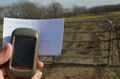
We were close!
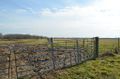
The chained fence and cows kept us away...


Achievements
Strictly speaking, there was no sign saying "No Trespassing", but the fence seemed to imply that. And the cows.
StatMan22 and Buttercup earned the No trespassing consolation prize
|