Difference between revisions of "2013-01-16 -35 149"
imported>1PE |
imported>1PE (→Photos) |
||
| Line 35: | Line 35: | ||
<gallery perrow="5"> | <gallery perrow="5"> | ||
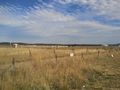
Image:2013-01-16_-35+149_navaids.jpg|Navaids, hangar, and electric fence | Image:2013-01-16_-35+149_navaids.jpg|Navaids, hangar, and electric fence | ||
| − | + | Image:2013-01-16_-35_149_fence-proof.jpg|Along the line of the fence. | |
</gallery> | </gallery> | ||
Revision as of 13:04, 16 January 2013

| Wed 16 Jan 2013 in -35,149: -35.2845831, 149.1941117 geohashing.info google osm bing/os kml crox |
Location
In a field beside Majura Road, off the north end of the Canberra Airport runway, adjacent to the precision landing navigation aids.
Participants
- 1PE
Plans
1PE
Go after work, and then go shopping at the nearby Costco mega-mart.
Expedition
1PE
I had found from the maps that the site was opposite a fence on the other side of the road. I parked opposite the fence, and found that there was a discrepancy between my map-calculated site and the GPS... of 7 paces.
The fence into the field can be seen in one picture; it is a double fence, announcing that it is part of the adjacent military firing range and that trespassing is not a good idea. The second fence is electrified. So, I did not go in. I was within about 25m of the hash point.
I took pictures at the site then went shopping.
Photos
Navaids, hangar, and electric fence
Along the line of the fence.

