Difference between revisions of "2013-01-19 61 23"
imported>Teukkam ([retro picture] East [http://www.openstreetmap.org/?lat=61.41100000&lon=23.54400000&zoom=16&layers=B000FTF @61.4110,23.5440]) |
m |
||
| (5 intermediate revisions by 2 users not shown) | |||
| Line 1: | Line 1: | ||
| − | |||
<!-- If you did not specify these parameters in the template, please substitute appropriate values for IMAGE, LAT, LON, and DATE (YYYY-MM-DD format) | <!-- If you did not specify these parameters in the template, please substitute appropriate values for IMAGE, LAT, LON, and DATE (YYYY-MM-DD format) | ||
| Line 18: | Line 17: | ||
__NOTOC__ | __NOTOC__ | ||
== Location == | == Location == | ||
| − | + | Pirkkala, west of Tampere-Pirkkala airport | |
== Participants == | == Participants == | ||
<!-- who attended: If you link to your wiki user name in this section, your expedition will be picked up by the various statistics generated for geohashing. You may use three tildes ~ as a shortcut to automatically insert the user signature of the account you are editing with. | <!-- who attended: If you link to your wiki user name in this section, your expedition will be picked up by the various statistics generated for geohashing. You may use three tildes ~ as a shortcut to automatically insert the user signature of the account you are editing with. | ||
--> | --> | ||
| + | *[[User:Teukkam|TeukkaM]] | ||
== Plans == | == Plans == | ||
| Line 29: | Line 29: | ||
== Expedition == | == Expedition == | ||
<!-- how it all turned out. your narrative goes here. --> | <!-- how it all turned out. your narrative goes here. --> | ||
| + | === TeukkaM's retro expedition on 2013-01-21 === | ||
| + | |||
| + | This was an example of a perfect hash on an imperfect day. The hashpoint was in Pirkkala, where I drive trough daily on my commute to work. Sadly, this wasn't a working day and secondly, my car was rented out for the weekend. So I decided to recreate the expedition on the next working day like it would have happened on a weekday. A closer study of the hashpoint on National Land Survey topo maps showed a non-driveable track of some kind going straight through the hashpoint, so this seemed too good to miss entirely. Also, the track was not in OpenStreetMap, so an OSM survey would be another good excuse for a retro expedition. | ||
| + | |||
| + | Everything clicked to place still when approaching the site. Though the main road was not plowed and impossible to park along, there happened to be a turning place just where the trail was supposedly starting. An abandoned junk refrigerator and the absence of footprints or tyre tracks gave away that this wasn't a place where people visit regularly either. I found the start of the trail, though at first look it was heavily snowed in. What's more, small trees were bent down to almost conceal that there ever was a road. A little further down the contours of the snow indicated that the trail was probably a forestry vehicle track. There were also plenty of animal tracks going along the trail, so this was clearly the easiest route through the forest. I stopped to take the below photographs when I reached the hashpoint within three decimal accuracy, and decided this was enough proof required for a retro expedition. Should someone wander here before the next snowfall, I scribbled the standard greeting in the snow. I continued on the trail as long as it was somehow visible in the snow to get as long a trace as possible for OSM. As I turned around, there were some F/A-18 Hornet fighters scrambling into the air with great noise from the nearby air base. | ||
== Tracklog == | == Tracklog == | ||
| Line 46: | Line 51: | ||
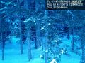
Image:2013-01-19_61_23_09-42-02-605.jpg | East [http://www.openstreetmap.org/?lat=61.41100000&lon=23.54400000&zoom=16&layers=B000FTF @61.4110,23.5440] | Image:2013-01-19_61_23_09-42-02-605.jpg | East [http://www.openstreetmap.org/?lat=61.41100000&lon=23.54400000&zoom=16&layers=B000FTF @61.4110,23.5440] | ||
| + | |||
| + | Image:2013-01-19_61_23_09-42-25-877.jpg | South [http://www.openstreetmap.org/?lat=61.41100000&lon=23.54400000&zoom=16&layers=B000FTF @61.4110,23.5440] | ||
| + | |||
| + | Image:2013-01-19_61_23_09-49-58-565.jpg | Lone pine illuminated by the rising sun [http://www.openstreetmap.org/?lat=61.41160000&lon=23.54300000&zoom=16&layers=B000FTF @61.4116,23.5430] | ||
</gallery> | </gallery> | ||
| Line 51: | Line 60: | ||
{{#vardefine:ribbonwidth|800px}} | {{#vardefine:ribbonwidth|800px}} | ||
<!-- Add any achievement ribbons you earned below, or remove this section --> | <!-- Add any achievement ribbons you earned below, or remove this section --> | ||
| − | + | {{OpenStreetMap achievement | |
| + | | latitude = 61 | ||
| + | | longitude = 23 | ||
| + | | date = 2013-01-19 | ||
| + | | OSMlink = 14734390 | ||
| + | | name = Teukkam | ||
| + | }} | ||
<!-- =============== USEFUL CATEGORIES FOLLOW ================ | <!-- =============== USEFUL CATEGORIES FOLLOW ================ | ||
Delete the next line ONLY if you have chosen the appropriate categories below. If you are unsure, don't worry. People will read your report and help you with the classification. --> | Delete the next line ONLY if you have chosen the appropriate categories below. If you are unsure, don't worry. People will read your report and help you with the classification. --> | ||
| − | |||
<!-- Potential categories. Please include all the ones appropriate to your expedition --> | <!-- Potential categories. Please include all the ones appropriate to your expedition --> | ||
| Line 62: | Line 76: | ||
--> | --> | ||
| − | + | ||
| − | [[Category: | + | [[Category:Retro meetup]] |
| + | <!-- | ||
-- and one or more of -- | -- and one or more of -- | ||
[[Category:Expeditions with photos]] | [[Category:Expeditions with photos]] | ||
| Line 70: | Line 85: | ||
--> | --> | ||
| − | + | ||
| − | [[Category: | + | [[Category:Retro coordinates reached]] |
| − | + | <!-- or if you failed :( | |
[[Category:Coordinates not reached]] | [[Category:Coordinates not reached]] | ||
-- and a reason -- | -- and a reason -- | ||
| Line 90: | Line 105: | ||
(Don't forget to delete this final close comment marker) --> | (Don't forget to delete this final close comment marker) --> | ||
| + | {{location|FI|11}} | ||
Latest revision as of 18:00, 18 March 2022
| Sat 19 Jan 2013 in 61,23: 61.4105615, 23.5437263 geohashing.info google osm bing/os kml crox |
Location
Pirkkala, west of Tampere-Pirkkala airport
Participants
Plans
Expedition
TeukkaM's retro expedition on 2013-01-21
This was an example of a perfect hash on an imperfect day. The hashpoint was in Pirkkala, where I drive trough daily on my commute to work. Sadly, this wasn't a working day and secondly, my car was rented out for the weekend. So I decided to recreate the expedition on the next working day like it would have happened on a weekday. A closer study of the hashpoint on National Land Survey topo maps showed a non-driveable track of some kind going straight through the hashpoint, so this seemed too good to miss entirely. Also, the track was not in OpenStreetMap, so an OSM survey would be another good excuse for a retro expedition.
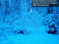
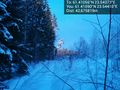
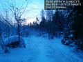
Everything clicked to place still when approaching the site. Though the main road was not plowed and impossible to park along, there happened to be a turning place just where the trail was supposedly starting. An abandoned junk refrigerator and the absence of footprints or tyre tracks gave away that this wasn't a place where people visit regularly either. I found the start of the trail, though at first look it was heavily snowed in. What's more, small trees were bent down to almost conceal that there ever was a road. A little further down the contours of the snow indicated that the trail was probably a forestry vehicle track. There were also plenty of animal tracks going along the trail, so this was clearly the easiest route through the forest. I stopped to take the below photographs when I reached the hashpoint within three decimal accuracy, and decided this was enough proof required for a retro expedition. Should someone wander here before the next snowfall, I scribbled the standard greeting in the snow. I continued on the trail as long as it was somehow visible in the snow to get as long a trace as possible for OSM. As I turned around, there were some F/A-18 Hornet fighters scrambling into the air with great noise from the nearby air base.
Tracklog
Photos
OK so this could be a path in summertime... @61.4172,23.5400
West @61.4109,23.5441
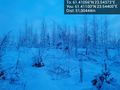
North @61.4110,23.5440
East @61.4110,23.5440
South @61.4110,23.5440
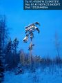
Lone pine illuminated by the rising sun @61.4116,23.5430


Achievements
Teukkam earned the OpenStreetMap achievement
|