Difference between revisions of "2013-02-28 37 -122"
From Geohashing
imported>Anniepoo (→Photos) |
imported>Palmpje m (I cycled from the town of St Andrews to the location. The co-ordinates were unfortunately in a very muddy field which was private land and had pigs on, so whilst I ruined my trousers dashing in to the pig pen and out again, I have no picture of me on the) |
||
| Line 66: | Line 66: | ||
| − | <!-- =============== USEFUL CATEGORIES FOLLOW ================ | + | <!-- =============== USEFUL CATEGORIES FOLLOW ================ --> |
| − | |||
| − | |||
| − | |||
| − | |||
| − | |||
| − | |||
| − | |||
| − | |||
| − | |||
[[Category:Expeditions]] | [[Category:Expeditions]] | ||
| − | |||
[[Category:Expeditions with photos]] | [[Category:Expeditions with photos]] | ||
| − | |||
| − | |||
| − | |||
| − | |||
| − | |||
| − | |||
| − | |||
| − | |||
| − | |||
[[Category:Coordinates not reached]] | [[Category:Coordinates not reached]] | ||
| − | |||
| − | |||
| − | |||
| − | |||
| − | |||
[[Category:Not reached - No public access]] | [[Category:Not reached - No public access]] | ||
| − | |||
| − | |||
| − | |||
| − | |||
| − | |||
| − | |||
| − | |||
| − | |||
Revision as of 05:45, 4 June 2013
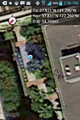
| Thu 28 Feb 2013 in 37,-122: 37.8308013, -122.2895187 geohashing.info google osm bing/os kml crox |
Location
In a courtyard near the corner of hubbard and park in Emeryville.
When we went, it turned out it was inside the building, which wasn't public.
Participants
Diana
Plans
Go past the hash, get something to eat, go to a bookstore and check out illustrations for the planned art installation.
Expedition
The courtyard was beautiful - a very nice little oasis, and a fun end to the hash.
Unfortunately, the hash point was inside the building, not in a public place, and despite the GPS dance, we couldn't get inside the circle of uncertainty.
Tracklog
Photos

Diana at point of closest approach

Annie at point of closest approach
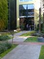
The courtyard
Dang!!


