Difference between revisions of "2013-03-02 38 -120"
From Geohashing
imported>Lucky91xj (→Participants) |
m |
||
| (2 intermediate revisions by 2 users not shown) | |||
| Line 30: | Line 30: | ||
2013-03-02 38 -120 EBMUD sign.jpg|East Bay MUD | 2013-03-02 38 -120 EBMUD sign.jpg|East Bay MUD | ||
2013_03_02_38_-120_Lucky_dots.jpg|Ok, 1.16 miles... | 2013_03_02_38_-120_Lucky_dots.jpg|Ok, 1.16 miles... | ||
| + | 2013-03-02 38 -120 no pass.jpg | ||
</gallery> | </gallery> | ||
| Line 38: | Line 39: | ||
[[Category:Expeditions]] | [[Category:Expeditions]] | ||
[[Category:Expeditions with photos]] | [[Category:Expeditions with photos]] | ||
| + | [[Category:Coordinates not reached]] | ||
[[Category:Not reached - No public access]] | [[Category:Not reached - No public access]] | ||
| + | {{location|US|CA|SJ}} | ||
Latest revision as of 19:33, 11 September 2021
| Sat 2 Mar 2013 in 38,-120: 38.1726841, -120.9984565 geohashing.info google osm bing/os kml crox |
Location
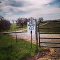
On East Bay Municipal Untilty District property, down a country road.
Participants
Plans
Sort of a lark. I had half an hour free and found that I was 10 miles from the hash.
Expedition
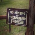
I drove into the country as far as I could, but was blocked by EBMUD No Trespassing signs.
Photos

Lucky and the blockade.
East Bay MUD
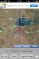
Ok, 1.16 miles...