Difference between revisions of "2013-03-06 41 -90"
imported>Hempmage |
imported>Hempmage |
||
| Line 5: | Line 5: | ||
| graticule_name=Quad Cities | | graticule_name=Quad Cities | ||
| graticule_link=Quad Cities}} | | graticule_link=Quad Cities}} | ||
| − | + | ==The Location== | |
| − | ==Participants== | + | Along the side of the road, surrounded by nothing but some trees, fields, and a bunch of snow. |
| + | ==The Participants== | ||
* [[User:Hempmage|Hempmage]] | * [[User:Hempmage|Hempmage]] | ||
==The Plan== | ==The Plan== | ||
Revision as of 03:58, 7 March 2013
| Wed 6 Mar 2013 in Quad Cities: 41.5897992, -90.4811346 geohashing.info google osm bing/os kml crox |
The Location
Along the side of the road, surrounded by nothing but some trees, fields, and a bunch of snow.
The Participants
The Plan
This being my first geohashing attempt, I was excited to get going. I grabbed my GPS and was almost out the door when I realized with great dismay that my GPS does not display coordinates with enough detail to really be useful. Out came Google Maps, and a crude hand-drawn map later, I was off.
The Expedition
It was a quick and uneventful drive toward the hashpoint, stopping for a slushy at a gas station nearby. The spot itself was in the ditch of a county road surrounded by the frozen fields of Iowa. I parked on the side of the road, consulted my notebook-paper map and walked a few meters to where my map placed the hashpoint- using a tree and telephone poles as guides. Content with finding the hashpoint, I drank my slushy and attempted to make a snow android (snandroid?) which refused to stay together. A few trucks passed, wondering no doubt why there was a man with a slushy playing with snow in the ditch. Success!
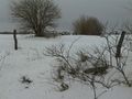
It wasn't as cold as it looks...

...it was, however, very bright due to the snow.

