Difference between revisions of "2013-03-06 43 -116"
imported>Eldin (An expedition message sent via Geohash Droid for Android.) |
imported>FippeBot m (Location) |
||
| (7 intermediate revisions by 2 users not shown) | |||
| Line 1: | Line 1: | ||
| − | |||
| − | |||
| − | |||
| − | |||
| − | |||
| − | |||
| − | |||
| − | |||
| − | |||
| − | |||
{{meetup graticule | {{meetup graticule | ||
| lat=43 | | lat=43 | ||
| Line 15: | Line 5: | ||
}} | }} | ||
| − | + | ||
__NOTOC__ | __NOTOC__ | ||
== Location == | == Location == | ||
| − | + | Just inside Nampa, on or near the property of a sand and gravel company. | |
== Participants == | == Participants == | ||
| − | + | *[[User:Eldin | Eldin]] | |
| − | + | ||
| + | == Expedition == | ||
| − | == | + | *As I feared, there seems to be no public access. -- [[User:Eldin|Eldin]] ([[User talk:Eldin|talk]]) [http://www.openstreetmap.org/?lat=43.58868102&lon=-116.48362300&zoom=16&layers=B000FTF @43.5887,-116.4836] 21:50, 6 March 2013 (MST) |
| − | |||
| − | + | I was worried that there might not be any public access, but I was unsure. And since hashpoints within 10 miles of home are a bit of a rarity, I decided to try for it. I parked my car about 2/3 of a mile from the hash point, and proceeded to walk. Initially, I was encouraged by a lack of 'no trespassing' signs or closed gates. Walking along the edges of plowed fields, I was able to get to within 720ft of the coordinates before I reached fences that I was unable to pass. I took a few pictures, which I will post once I get them off the camera. | |
| − | |||
| − | + | This hash reminded me of how out of shape I've gotten over the last year. I'll have to get onto an exercise program of some sort to remedy that. | |
| − | |||
== Photos == | == Photos == | ||
| − | + | ||
| − | |||
| − | |||
<gallery perrow="5"> | <gallery perrow="5"> | ||
| + | File:2013 03 06 43 -116 truck1.jpg | The remains of an old milk delivery truck, in the vicinity of the hash coordinates. | ||
| + | File:2013 03 06 43 -116 truck2.jpg | Where the cab of the truck used to be. | ||
| + | File:2013 03 06 43 -116 gate.jpg | The coordinates were about 800ft on the other side of this gate. | ||
</gallery> | </gallery> | ||
== Achievements == | == Achievements == | ||
| − | {{ | + | {{No trespassing |
| − | + | | latitude = 43 | |
| − | + | | longitude = -116 | |
| − | + | | date = 2013-03-06 | |
| − | + | | name = [[User:Eldin | Eldin]] | |
| − | + | }} | |
| − | [[ | ||
| − | |||
| − | |||
| − | |||
| − | |||
| − | |||
[[Category:Expeditions]] | [[Category:Expeditions]] | ||
| − | |||
[[Category:Expeditions with photos]] | [[Category:Expeditions with photos]] | ||
| − | |||
| − | |||
| − | |||
| − | |||
| − | |||
| − | |||
| − | |||
| − | |||
| − | |||
[[Category:Coordinates not reached]] | [[Category:Coordinates not reached]] | ||
| − | |||
| − | |||
| − | |||
| − | |||
| − | |||
[[Category:Not reached - No public access]] | [[Category:Not reached - No public access]] | ||
| − | + | {{location|US|ID|CN}} | |
| − | |||
| − | |||
| − | |||
| − | |||
| − | |||
| − | |||
| − | |||
Latest revision as of 01:17, 14 August 2019
| Wed 6 Mar 2013 in 43,-116: 43.5897992, -116.4811346 geohashing.info google osm bing/os kml crox |
Location
Just inside Nampa, on or near the property of a sand and gravel company.
Participants
Expedition
- As I feared, there seems to be no public access. -- Eldin (talk) @43.5887,-116.4836 21:50, 6 March 2013 (MST)
I was worried that there might not be any public access, but I was unsure. And since hashpoints within 10 miles of home are a bit of a rarity, I decided to try for it. I parked my car about 2/3 of a mile from the hash point, and proceeded to walk. Initially, I was encouraged by a lack of 'no trespassing' signs or closed gates. Walking along the edges of plowed fields, I was able to get to within 720ft of the coordinates before I reached fences that I was unable to pass. I took a few pictures, which I will post once I get them off the camera.
This hash reminded me of how out of shape I've gotten over the last year. I'll have to get onto an exercise program of some sort to remedy that.
Photos
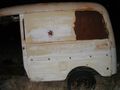
The remains of an old milk delivery truck, in the vicinity of the hash coordinates.
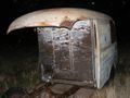
Where the cab of the truck used to be.
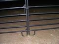
The coordinates were about 800ft on the other side of this gate.


Achievements
Eldin earned the No trespassing consolation prize
|