Difference between revisions of "2013-03-25 39 -77"
From Geohashing
imported>Jiml m (Expand Template) |
imported>Jiml m (Move details around) |
||
| Line 1: | Line 1: | ||
| − | |||
| − | |||
| − | |||
| − | |||
| − | |||
| − | |||
| − | |||
| − | |||
<!-- If you did not specify these parameters in the template, please substitute appropriate values for IMAGE, LAT, LON, and DATE (YYYY-MM-DD format) | <!-- If you did not specify these parameters in the template, please substitute appropriate values for IMAGE, LAT, LON, and DATE (YYYY-MM-DD format) | ||
| Line 35: | Line 27: | ||
== Plans == | == Plans == | ||
<!-- what were the original plans --> | <!-- what were the original plans --> | ||
| + | |||
| + | Depending on traffic, I may try to get there this evening before sunset. Would leave Rockville at 5. | ||
| + | *On my way there right now 45 minutes -- [[User:OfficeLinebacker|OfficeLinebacker]] ([[User talk:OfficeLinebacker|talk]]) [http://www.openstreetmap.org/?lat=39.07464123&lon=-77.16409207&zoom=16&layers=B000FTF @39.0746,-77.1641] 17:14, 25 March 2013 (EDT) | ||
== Expedition == | == Expedition == | ||
| Line 47: | Line 42: | ||
--> | --> | ||
<gallery perrow="5"> | <gallery perrow="5"> | ||
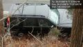
| + | Image:2013-03-25_39_-77_18-06-02-584.jpg | Made it! [http://www.openstreetmap.org/?lat=39.01085543&lon=-77.57442210&zoom=16&layers=B000FTF @39.0109,-77.5744] | ||
| + | Image:2013-03-25_39_-77_18-08-46-078.jpg | Thank goodness for 4 wheel drive. [http://www.openstreetmap.org/?lat=39.01098100&lon=-77.57395093&zoom=16&layers=B000FTF @39.0110,-77.5740] | ||
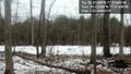
| + | Image:2013-03-25_39_-77_18-09-10-126.jpg | The view. [http://www.openstreetmap.org/?lat=39.01099087&lon=-77.57397577&zoom=16&layers=B000FTF @39.0110,-77.5740] | ||
</gallery> | </gallery> | ||
| Line 52: | Line 50: | ||
{{#vardefine:ribbonwidth|800px}} | {{#vardefine:ribbonwidth|800px}} | ||
<!-- Add any achievement ribbons you earned below, or remove this section --> | <!-- Add any achievement ribbons you earned below, or remove this section --> | ||
| + | |||
| + | * Land geohash | ||
| Line 58: | Line 58: | ||
[[Category:New report]] | [[Category:New report]] | ||
| − | + | [[Category:Expeditions]] | |
| − | |||
| − | [[Category: | ||
| − | |||
<!-- An actual expedition: | <!-- An actual expedition: | ||
Revision as of 01:00, 26 March 2013
| Mon 25 Mar 2013 in 39,-77: 39.0108820, -77.5744300 geohashing.info google osm bing/os kml crox |
Location
Participants
Plans
Depending on traffic, I may try to get there this evening before sunset. Would leave Rockville at 5.
- On my way there right now 45 minutes -- OfficeLinebacker (talk) @39.0746,-77.1641 17:14, 25 March 2013 (EDT)
Expedition
Tracklog
Photos

Made it! @39.0109,-77.5744
Thank goodness for 4 wheel drive. @39.0110,-77.5740
The view. @39.0110,-77.5740


Achievements
- Land geohash