Difference between revisions of "2013-03-27 43 -116"
imported>Eldin (But this barbed wire fence is in the way. [http://www.openstreetmap.org/?lat=43.55610000&lon=-116.13600000&zoom=16&layers=B000FTF @43.5561,-116.1360]) |
imported>FippeBot m (Location) |
||
| (4 intermediate revisions by one other user not shown) | |||
| Line 1: | Line 1: | ||
| − | |||
| − | |||
| − | |||
| − | |||
| − | |||
| − | |||
| − | |||
| − | |||
| − | |||
{{meetup graticule | {{meetup graticule | ||
| lat=43 | | lat=43 | ||
| Line 15: | Line 6: | ||
}} | }} | ||
| − | + | ||
__NOTOC__ | __NOTOC__ | ||
== Location == | == Location == | ||
| − | + | Close to a park and several historical sites, in southeast Boise. | |
== Participants == | == Participants == | ||
| − | + | * [[User:Eldin | Eldin]] | |
| − | |||
| − | == | + | == Expedition == |
| − | + | When I checked the hash on my lunch break, I noticed that the coordinates were only about 8 miles from my office. From satellite imagery, the area looked to be on public land. It was near an area that has hiking trails following the route of the historic Oregon Trail. I'd heard rumors that following this trail is hazardous, with a high risk of [[http://knowyourmeme.com/memes/you-have-died-of-dysentery/ dying of dysentery]]. But undaunted, I set out after work to attempt to reach the hash. | |
| − | + | I parked at the trailhead, and and hiked along the trail for about a mile before coming to a fence running parallel to the trail, between me and the hash. I followed the fence for a while towards the closest approach of the trail to the hash, looking for a way around or through the fence. But eventually it was getting close to sunset (and signs had indicated that the park on my side of the fence closes at sunset), and I could see that the fence went on far enough that there was no way I was reaching the hash in time to get back to the car before dark, so I headed back. I took some pictures at the closest approach I was able to make to the hash (about 330m). | |
| − | + | ||
| + | Looking at the map, it seemed possible that the hash might be reachable from the other side, so I drove around to check (it was only a little out of my way to do so). However, upon further investigation, I discovered that the hash is in fact on private property and unreachable without crossing a fence. | ||
*Blocked by a fence. -- [[User:Eldin|Eldin]] ([[User talk:Eldin|talk]]) [http://www.openstreetmap.org/?lat=43.53862437&lon=-116.10670215&zoom=16&layers=B000FTF @43.5386,-116.1067] 20:01, 27 March 2013 (MDT) | *Blocked by a fence. -- [[User:Eldin|Eldin]] ([[User talk:Eldin|talk]]) [http://www.openstreetmap.org/?lat=43.53862437&lon=-116.10670215&zoom=16&layers=B000FTF @43.5386,-116.1067] 20:01, 27 March 2013 (MDT) | ||
| − | == | + | |
| − | + | *Going to attempt to find access from the opposite direction. -- [[User:Eldin|Eldin]] ([[User talk:Eldin|talk]]) [http://www.openstreetmap.org/?lat=43.54305418&lon=-116.11450303&zoom=16&layers=B000FTF @43.5431,-116.1145] 20:19, 27 March 2013 (MDT) | |
| + | |||
| + | *No luck. The fence appears to completely encircle the hash. -- [[User:Eldin|Eldin]] ([[User talk:Eldin|talk]]) [http://www.openstreetmap.org/?lat=43.53114525&lon=-116.09514073&zoom=16&layers=B000FTF @43.5311,-116.0951] 20:28, 27 March 2013 (MDT) | ||
== Photos == | == Photos == | ||
| − | |||
| − | |||
| − | |||
<gallery perrow="5"> | <gallery perrow="5"> | ||
| Line 49: | Line 39: | ||
{{#vardefine:ribbonwidth|800px}} | {{#vardefine:ribbonwidth|800px}} | ||
<!-- Add any achievement ribbons you earned below, or remove this section --> | <!-- Add any achievement ribbons you earned below, or remove this section --> | ||
| + | {{No trespassing | ||
| + | | latitude = 43 | ||
| + | | longitude = -116 | ||
| + | | date = 2013-03-27 | ||
| + | | name = [[User:Eldin | Eldin]] | ||
| + | | distance = 330m | ||
| + | }} | ||
| − | |||
| − | |||
| − | |||
| − | |||
| − | |||
| − | |||
| − | |||
| − | |||
| − | |||
| − | |||
| − | |||
[[Category:Expeditions]] | [[Category:Expeditions]] | ||
| − | |||
[[Category:Expeditions with photos]] | [[Category:Expeditions with photos]] | ||
| − | |||
| − | |||
| − | |||
| − | |||
| − | |||
| − | |||
| − | |||
| − | |||
| − | |||
[[Category:Coordinates not reached]] | [[Category:Coordinates not reached]] | ||
| − | |||
| − | |||
| − | |||
| − | |||
| − | |||
[[Category:Not reached - No public access]] | [[Category:Not reached - No public access]] | ||
| − | + | {{location|US|ID|AA}} | |
| − | |||
| − | |||
| − | |||
| − | |||
| − | |||
| − | |||
| − | |||
Latest revision as of 01:36, 14 August 2019
| Wed 27 Mar 2013 in 43,-116: 43.5357028, -116.1074312 geohashing.info google osm bing/os kml crox |
Location
Close to a park and several historical sites, in southeast Boise.
Participants
Expedition
When I checked the hash on my lunch break, I noticed that the coordinates were only about 8 miles from my office. From satellite imagery, the area looked to be on public land. It was near an area that has hiking trails following the route of the historic Oregon Trail. I'd heard rumors that following this trail is hazardous, with a high risk of [dying of dysentery]. But undaunted, I set out after work to attempt to reach the hash.
I parked at the trailhead, and and hiked along the trail for about a mile before coming to a fence running parallel to the trail, between me and the hash. I followed the fence for a while towards the closest approach of the trail to the hash, looking for a way around or through the fence. But eventually it was getting close to sunset (and signs had indicated that the park on my side of the fence closes at sunset), and I could see that the fence went on far enough that there was no way I was reaching the hash in time to get back to the car before dark, so I headed back. I took some pictures at the closest approach I was able to make to the hash (about 330m).
Looking at the map, it seemed possible that the hash might be reachable from the other side, so I drove around to check (it was only a little out of my way to do so). However, upon further investigation, I discovered that the hash is in fact on private property and unreachable without crossing a fence.
- Blocked by a fence. -- Eldin (talk) @43.5386,-116.1067 20:01, 27 March 2013 (MDT)
- Going to attempt to find access from the opposite direction. -- Eldin (talk) @43.5431,-116.1145 20:19, 27 March 2013 (MDT)
- No luck. The fence appears to completely encircle the hash. -- Eldin (talk) @43.5311,-116.0951 20:28, 27 March 2013 (MDT)
Photos
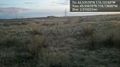
Coordinates are about half way to that building. @43.5561,-116.1360
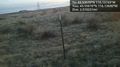
But this barbed wire fence is in the way. @43.5561,-116.1360


Achievements
Eldin earned the No trespassing consolation prize
|