Difference between revisions of "2013-03-28 43 -116"
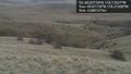
imported>Eldin ([live picture] One of several signs informing me that today's hash will not be reached. [http://www.openstreetmap.org/?lat=43.63750000&lon=-116.41100000&zoom=16&layers=B000FTF @43.6375,-116.4110]) |
imported>Eldin |
||
| Line 1: | Line 1: | ||
| − | |||
| − | |||
| − | |||
| − | |||
| − | |||
| − | |||
| − | |||
| − | |||
| − | |||
| − | |||
{{meetup graticule | {{meetup graticule | ||
| lat=43 | | lat=43 | ||
| Line 15: | Line 5: | ||
}} | }} | ||
| − | |||
__NOTOC__ | __NOTOC__ | ||
== Location == | == Location == | ||
| − | + | In the Boise foothills. | |
== Participants == | == Participants == | ||
| − | + | * [[User:Eldin|Eldin]] | |
| − | |||
| − | |||
| − | |||
| − | |||
== Expedition == | == Expedition == | ||
| − | + | The hash today was less than 5 miles from my office. So when I found myself with a few hours to kill in the afternoon while waiting for everyone else to leave so I could bring down some systems for maintenance, I decided to go for it. There was a trail on the map which looked to go relatively close to the hash, so I headed for the trailhead. As soon as I reached the trailhead I saw signs stating that leaving marked trails was not allowed, so I set out walking without much hope of reaching the hash. But I wanted to get as close as possible anyway. It was a beautiful spring day outside, so it was an enjoyable walk along a trail in the hills. I passed many pedestrians, bicyclists and dogs on the path, but none of them appeared to be geohashing. After walking about half a mile, I arrived at the nearest approach of the trail to the hash (about 750 ft). I took some pictures of the area around the hash, and some pictures of Boise spread out in the valley below. I also took a picture of my not-quite-a-grin. Then I kept walking up the trail, away from the hash for a while. While on the trail (but not no near the hash), I got a picture of one of the many signs in the area asking that people stay on marked trails. Although it was disappointing not reaching the hash (3rd 'No Public Access' hash in 3 days), I did have a good time. | |
| − | |||
*No public access, again. -- [[User:Eldin|Eldin]] ([[User talk:Eldin|talk]]) [http://www.openstreetmap.org/?lat=43.67352132&lon=-116.17216228&zoom=16&layers=B000FTF @43.6735,-116.1722] 17:06, 28 March 2013 (MDT) | *No public access, again. -- [[User:Eldin|Eldin]] ([[User talk:Eldin|talk]]) [http://www.openstreetmap.org/?lat=43.67352132&lon=-116.17216228&zoom=16&layers=B000FTF @43.6735,-116.1722] 17:06, 28 March 2013 (MDT) | ||
| − | |||
| − | |||
== Photos == | == Photos == | ||
| − | |||
| − | |||
| − | |||
<gallery perrow="5"> | <gallery perrow="5"> | ||
| Line 45: | Line 24: | ||
Image:2013-03-28_43_-116_17-16-38-343.jpg | Me, at my closest approach to the coordinates. | Image:2013-03-28_43_-116_17-16-38-343.jpg | Me, at my closest approach to the coordinates. | ||
| − | Image:2013-03-28_43_-116_17-22-02-341.jpg | One of several signs informing me that today's hash will not be reached. | + | Image:2013-03-28_43_-116_17-22-02-341.jpg | One of several signs informing me that today's hash will not be reached. |
</gallery> | </gallery> | ||
== Achievements == | == Achievements == | ||
{{#vardefine:ribbonwidth|800px}} | {{#vardefine:ribbonwidth|800px}} | ||
| − | + | {{No trespassing | |
| + | | latitude = 43 | ||
| + | | longitude = -116 | ||
| + | | date = 2013-03-28 | ||
| + | | name = [[User:Eldin|Eldin]] | ||
| + | | distance = 230m | ||
| + | }} | ||
| − | |||
| − | |||
[[Category:New report]] | [[Category:New report]] | ||
| − | |||
| − | |||
| − | |||
| − | |||
| − | |||
| − | |||
| − | |||
[[Category:Expeditions]] | [[Category:Expeditions]] | ||
| − | |||
[[Category:Expeditions with photos]] | [[Category:Expeditions with photos]] | ||
| − | |||
| − | |||
| − | |||
| − | |||
| − | |||
| − | |||
| − | |||
| − | |||
| − | |||
[[Category:Coordinates not reached]] | [[Category:Coordinates not reached]] | ||
| − | |||
| − | |||
| − | |||
| − | |||
| − | |||
[[Category:Not reached - No public access]] | [[Category:Not reached - No public access]] | ||
| − | |||
| − | |||
| − | |||
| − | |||
| − | |||
| − | |||
| − | |||
| − | |||
Revision as of 02:07, 29 March 2013
| Thu 28 Mar 2013 in 43,-116: 43.6717396, -116.1702692 geohashing.info google osm bing/os kml crox |
Location
In the Boise foothills.
Participants
Expedition
The hash today was less than 5 miles from my office. So when I found myself with a few hours to kill in the afternoon while waiting for everyone else to leave so I could bring down some systems for maintenance, I decided to go for it. There was a trail on the map which looked to go relatively close to the hash, so I headed for the trailhead. As soon as I reached the trailhead I saw signs stating that leaving marked trails was not allowed, so I set out walking without much hope of reaching the hash. But I wanted to get as close as possible anyway. It was a beautiful spring day outside, so it was an enjoyable walk along a trail in the hills. I passed many pedestrians, bicyclists and dogs on the path, but none of them appeared to be geohashing. After walking about half a mile, I arrived at the nearest approach of the trail to the hash (about 750 ft). I took some pictures of the area around the hash, and some pictures of Boise spread out in the valley below. I also took a picture of my not-quite-a-grin. Then I kept walking up the trail, away from the hash for a while. While on the trail (but not no near the hash), I got a picture of one of the many signs in the area asking that people stay on marked trails. Although it was disappointing not reaching the hash (3rd 'No Public Access' hash in 3 days), I did have a good time.
- No public access, again. -- Eldin (talk) @43.6735,-116.1722 17:06, 28 March 2013 (MDT)
Photos
Hash is just over there.

Me, at my closest approach to the coordinates.
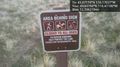
One of several signs informing me that today's hash will not be reached.


Achievements
Eldin earned the No trespassing consolation prize
|