Difference between revisions of "2013-03-30 38 -77"
imported>OfficeLinebacker ([live picture] The view [http://www.openstreetmap.org/?lat=38.31102157&lon=-77.07586420&zoom=16&layers=B000FTF @38.3110,-77.0759]) |
imported>OfficeLinebacker ([live picture] I decided to try to drive on that little car track in this is the end of the car track [http://www.openstreetmap.org/?lat=38.31164183&lon=-77.07268455&zoom=16&layers=B000FTF @38.3116,-77.0727]) |
||
| Line 57: | Line 57: | ||
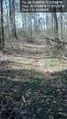
Image:2013-03-30_38_-77_15-18-11-074.jpg | The view [http://www.openstreetmap.org/?lat=38.31102157&lon=-77.07586420&zoom=16&layers=B000FTF @38.3110,-77.0759] | Image:2013-03-30_38_-77_15-18-11-074.jpg | The view [http://www.openstreetmap.org/?lat=38.31102157&lon=-77.07586420&zoom=16&layers=B000FTF @38.3110,-77.0759] | ||
| + | |||
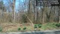
| + | Image:2013-03-30_38_-77_15-33-33-961.jpg | I decided to try to drive on that little car track in this is the end of the car track [http://www.openstreetmap.org/?lat=38.31164183&lon=-77.07268455&zoom=16&layers=B000FTF @38.3116,-77.0727] | ||
</gallery> | </gallery> | ||
Revision as of 19:33, 30 March 2013
| Sat 30 Mar 2013 in 38,-77: 38.3109856, -77.0758843 geohashing.info google osm bing/os kml crox |
Location
In some woods about 500 ft off Windsor drive in King George Virginia
Participants
OfficeLinebacker (talk)OfficeLinebacker
Plans
I hope to leave Rockville around 12:30 pm and get there around 2. Then head up a different way to pick up Allison, and from there go to the Cumberland MD geohash for today.
I hope to earn the Tron achievement for today's expeditions.
Expedition
Tracklog
Photos
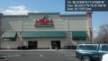
Traffic is terrible and I'm starving @38.6222,-76.9177
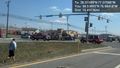
Really bad car accident I saw on the way there @38.5389,-76.9842
Huge power plant or fuel depot at the Potomac River @38.3634,-76.9832
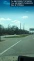
The view from the street 500 ft away @38.3108,-77.0777
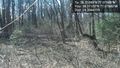
came upon a narrow car pass in the woods @38.3109,-77.0763

Silly grin @38.3110,-77.0759
The view @38.3110,-77.0759
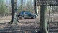
I decided to try to drive on that little car track in this is the end of the car track @38.3116,-77.0727


Achievements