Difference between revisions of "2013-03-30 46 11"
imported>Werther (→Photos) |
imported>Werther (→Achievements) |
||
| Line 63: | Line 63: | ||
== Achievements == | == Achievements == | ||
| − | {{ | + | {{Drowned rat geohash | latitude = 46 | longitude = 11 | date = date 2013-03-30 | name = Werther| reason = heavy rain an umbrella could only partially cover| honourable = yes |
| − | |||
| − | |||
<!-- =============== USEFUL CATEGORIES FOLLOW ================ | <!-- =============== USEFUL CATEGORIES FOLLOW ================ | ||
| − | |||
| − | |||
| − | |||
| − | |||
| − | |||
| − | |||
| − | |||
| − | |||
| − | |||
[[Category:Expeditions]] | [[Category:Expeditions]] | ||
| − | |||
[[Category:Expeditions with photos]] | [[Category:Expeditions with photos]] | ||
| − | |||
| − | |||
| − | |||
| − | |||
| − | |||
[[Category:Coordinates reached]] | [[Category:Coordinates reached]] | ||
| − | |||
| − | |||
| − | |||
| − | |||
| − | |||
| − | |||
| − | |||
| − | |||
| − | |||
| − | |||
| − | |||
| − | |||
| − | |||
| − | |||
| − | |||
| − | |||
| − | |||
| − | |||
Revision as of 19:49, 1 April 2013
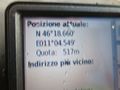
| Sat 30 Mar 2013 in 46,11: 46.3109856, 11.0758843 geohashing.info google osm bing/os kml crox |
Location
The side of a country road just outside Segno, Trento.
Participants
Plans
This one looks fairly easy, and pretty similar to my Banco expedition I took during Christams break. I'll take the Trento-Malé railway once again early in the afternoon, get off in Segno, walk through the small village and get to the hash, which is supposed to be located just outside the road. Like the Banco expedition, the scenery is going to be apple fields everywhere, and like that expedition I will have plenty of time to reach the hashpoint. Once I'm done I'll take the train back to Trento, either from Segno or, if I have time, I'll walk to the village of Taio and get on board there. The only possible downside might be the weather, as it has been raining all week and tomorrow should still be cloudy.
Expedition
In the end, it turned out to be more challenging than it looked like. The weather did prove to be a downside- it was pouring with rain- but that wasn't the only reason. If there is something I learned from today's expedition is that if life gives you lemons, be sure those lemons aren't moldy.
A bit of introduction, as short as possible. When I was organizing my trip yesterday, I googletransit'd a route from Trento to Segno starting at 13.30 (1.30 pm). Transit found a train at 13.35, and that worked perfectly for me so I didn't do any other queries. I took the bus at 13.10 from home and was at the train station at 13.20. There was a train departing at 13.27, and those were delightful news- hopefully I would have some more minutes and avoid being in a rush once in Segno. The FTM is a single-line railway, and the train was headed to the northern terminus of the line, Marilleva, so that looked just perfect. I went on board and the train left perfectly on time. It was almost empty too. I thought to myself "what a blessing", but the best had yet to come- it was an express train, skipping all minor stations. I knew there were a few during rush hours, but I had no clue I was on one of those. I was going to arrive in Segno even earlier! That was just perfect.
It was only when I was getting close to Segno that I noticed that the train was skipping MOST stations, and I remembered Segno to not be a remarkably big stop. I crossed my fingers, but the train didn't stop. Not all hope was lost though! Since I was going to have plenty of time in Segno, yesterday I had thought to not go back to the station once I had reached the hashpoint but keep going on walking on the road where the hashpoint was located until the next village/next station (Taio), and take the train from there. I had abandoned the idea, but since the train was approaching Taio I thought I'd just do the opposite, hoping that the GPS could lead me from there to the hashpoint. Aaaand the train skipped Taio as well. Now things were starting to get complicated, but luckily the train stopped at the following station, Dermulo. I had taken a Trento-bound train from there at 14.30 during my Banco expedition, so I could just take that back and get off in Segno- that's what I did.
I lost around 15 mins of time on this- that meant that I wasn't in a hurry, but couldn't take it too easy either. It was raining heavier than before, and it was a good kilometer uphill from the station. On the way, I met an old lady carrying an heavy bag and flowers. I offered to help her, and I carried the flowers to the cemetery, which was on the road to the hashpoint. It was a nice gesture and all, but this detour snatched another bit of time away- I had to rush. The GPS reception wasn't great, so I had trouble finding the right place. It turned out to be inside an apple field, just like in Banco, but very close to the road. I got in for a bit, but opted for a 'close enough' picture because I was seriously risking to miss the train back home.
So, despite the heavy rain and the train confusion, it turned out to be another pleasant expedition.
Tracklog
Photos
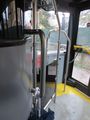
On the bus to the train station
My train to Marilleva (the express one)
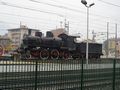
Steam locomotive parked in Trento rail yard
Dermulo once again
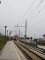
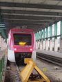
The train I took from Dermulo to Segno, leaving Segno's only platform
The closest I could get and bother to take a photo
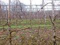
The hashpoint was right in this direction, I'd say before the second row of apple trees

Devastated-by-the-weather grin
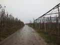
I love taking photos of roads in between apple trees
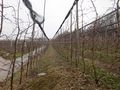
The hashpoint from south
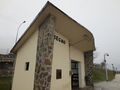
Segno station's waiting room


Photos will be uploaded later in the evening!
Achievements
{{Drowned rat geohash | latitude = 46 | longitude = 11 | date = date 2013-03-30 | name = Werther| reason = heavy rain an umbrella could only partially cover| honourable = yes