Difference between revisions of "2013-04-16 41 -71"
imported>Vbob |
imported>Vbob |
||
| Line 41: | Line 41: | ||
--> | --> | ||
<gallery perrow="5"> | <gallery perrow="5"> | ||
| + | 2013-04-16_41_-71_the_sign.jpg | Yes, there was this sign... | ||
| + | 2013-04-16_41_-71_the_dam.jpg | And a dam fine place it is | ||
| + | 2013-04-16_41_-71_the_falls.jpg | with lots of falling water | ||
| + | 2013-04-16_41_-71_the_math.jpg | GPS closing in - with math notes | ||
| + | 2013-04-16_41_-71_the_point.jpg | lost signal but counted paces to roots of fallen tree | ||
| + | 2013-04-16_41_-71_the_grin.jpg | the canonical foolish grin™ | ||
| + | 2013-04-16_41_-71_the_kiss.jpg | the celebration of life | ||
| + | 2013-04-16_41_-71_stacked_stones.jpg | stacked stones on old mill foundation | ||
| + | 2013-04-16_41_-71_the_trash.jpg | picked up someone else's beer trash | ||
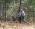
| + | 2013-04-16_41_-71_the_formal_attire.jpg | this is high formal for us | ||
</gallery> | </gallery> | ||
Revision as of 22:22, 16 April 2013
| Tue 16 Apr 2013 in 41,-71: 41.7922810, -71.6720159 geohashing.info google osm bing/os kml crox |
Location
One of those dam places back in the woods where you went to drink beer and smoke pot while in high school
Participants
Vbob and Bruce
Plans
Needed to take a day out of work to attend funeral of one of my oldest friends from high school days. Checked the day's hashpoint after the service - the point is just a hundred feet into the woods near a place we used to go drink beer and smoke pot (way) back in those high school days, it's a fine sunny day, and it's on the way to my mother's house. Time for a celebration of life!
Expedition
Tracklog
Photos
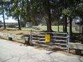
Yes, there was this sign...
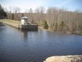
And a dam fine place it is
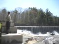
with lots of falling water
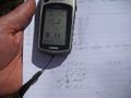
GPS closing in - with math notes
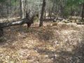
lost signal but counted paces to roots of fallen tree

the canonical foolish grin™
the celebration of life
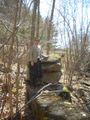
stacked stones on old mill foundation

picked up someone else's beer trash

this is high formal for us


Achievements