Difference between revisions of "2013-04-17 43 -116"
imported>Eldin ([live picture] No trespassing sign. [http://www.openstreetmap.org/?lat=43.86830000&lon=-116.49400000&zoom=16&layers=B000FTF @43.8683,-116.4940]) |
imported>FippeBot m (Location) |
||
| (3 intermediate revisions by one other user not shown) | |||
| Line 1: | Line 1: | ||
| − | |||
| − | |||
| − | |||
| − | |||
| − | |||
| − | |||
| − | |||
| − | |||
| − | |||
| − | |||
{{meetup graticule | {{meetup graticule | ||
| lat=43 | | lat=43 | ||
| Line 15: | Line 5: | ||
}} | }} | ||
| − | |||
__NOTOC__ | __NOTOC__ | ||
== Location == | == Location == | ||
| − | + | On the bank of the Payette River, just west of Emmett. | |
== Participants == | == Participants == | ||
| − | + | * [[User:Eldin |Eldin ]] | |
| − | + | * Borneo | |
== Plans == | == Plans == | ||
| − | + | The hash looked likely to be reachable, and was in an area where I could reasonably drag along a friend. | |
== Expedition == | == Expedition == | ||
| − | + | After work, I headed out. I stopped to pick up Borneo on the way, and we had a pleasant drive out to Emmett. It took a few wrong turns and winding back roads before we found a bridge to the correct side of the river, but we found our way nearly to the hash without dificulty. However, when we turned down what looked to be a road on the map to get to the river, it turned out to be a driveway servicing a few farm houses. We were unable to actually get to the river without crossing one of the fenced yards, though we were close enough to see the coordinates at that point. | |
| + | Unfortunately, nobody was home to ask permission at the home with the yard we needed to cross. So we turned around and looked for another approach farther up the river, but failed to find an approach to the riverbank without crossing private property with either fences or signs. Our nearest approach to the hash before we gave up was about 970ft (295m). After failing to reach the designated coordinates, we retreated to a Mexican restaurant which had been passed in route to the hash to enjoy a meal and commiserate about our lack of success. | ||
*No trespassing -- [[User:Eldin|Eldin]] ([[User talk:Eldin|talk]]) [http://www.openstreetmap.org/?lat=43.90114302&lon=-116.63207788&zoom=16&layers=B000FTF @43.9011,-116.6321] 19:30, 17 April 2013 (MDT) | *No trespassing -- [[User:Eldin|Eldin]] ([[User talk:Eldin|talk]]) [http://www.openstreetmap.org/?lat=43.90114302&lon=-116.63207788&zoom=16&layers=B000FTF @43.9011,-116.6321] 19:30, 17 April 2013 (MDT) | ||
| − | |||
| − | |||
== Photos == | == Photos == | ||
| − | |||
| − | |||
| − | |||
<gallery perrow="5"> | <gallery perrow="5"> | ||
| − | Image:2013-04-17_43_-116_19-31-32-425.jpg | No trespassing sign. | + | Image:2013-04-17_43_-116_19-31-32-425.jpg | No trespassing sign. |
</gallery> | </gallery> | ||
== Achievements == | == Achievements == | ||
{{#vardefine:ribbonwidth|800px}} | {{#vardefine:ribbonwidth|800px}} | ||
| − | + | {{No trespassing | |
| − | + | | latitude = 43 | |
| − | + | | longitude = -116 | |
| − | + | | date = 2013-04-17 | |
| − | + | | name = [[User:Eldin |Eldin ]] | |
| − | [[ | + | | distance = 295m |
| + | }} | ||
| − | |||
| − | |||
| − | |||
| − | |||
| − | |||
| − | |||
[[Category:Expeditions]] | [[Category:Expeditions]] | ||
| − | |||
[[Category:Expeditions with photos]] | [[Category:Expeditions with photos]] | ||
| − | |||
| − | |||
| − | |||
| − | |||
| − | |||
| − | |||
| − | |||
| − | |||
| − | |||
[[Category:Coordinates not reached]] | [[Category:Coordinates not reached]] | ||
| − | |||
| − | |||
| − | |||
| − | |||
| − | |||
[[Category:Not reached - No public access]] | [[Category:Not reached - No public access]] | ||
| − | + | {{location|US|ID|GE}} | |
| − | |||
| − | |||
| − | |||
| − | |||
| − | |||
| − | |||
| − | |||
Latest revision as of 01:55, 14 August 2019
| Wed 17 Apr 2013 in 43,-116: 43.9083023, -116.6462234 geohashing.info google osm bing/os kml crox |
Location
On the bank of the Payette River, just west of Emmett.
Participants
- Eldin
- Borneo
Plans
The hash looked likely to be reachable, and was in an area where I could reasonably drag along a friend.
Expedition
After work, I headed out. I stopped to pick up Borneo on the way, and we had a pleasant drive out to Emmett. It took a few wrong turns and winding back roads before we found a bridge to the correct side of the river, but we found our way nearly to the hash without dificulty. However, when we turned down what looked to be a road on the map to get to the river, it turned out to be a driveway servicing a few farm houses. We were unable to actually get to the river without crossing one of the fenced yards, though we were close enough to see the coordinates at that point.
Unfortunately, nobody was home to ask permission at the home with the yard we needed to cross. So we turned around and looked for another approach farther up the river, but failed to find an approach to the riverbank without crossing private property with either fences or signs. Our nearest approach to the hash before we gave up was about 970ft (295m). After failing to reach the designated coordinates, we retreated to a Mexican restaurant which had been passed in route to the hash to enjoy a meal and commiserate about our lack of success.
- No trespassing -- Eldin (talk) @43.9011,-116.6321 19:30, 17 April 2013 (MDT)
Photos
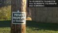
No trespassing sign.

Achievements
Eldin earned the No trespassing consolation prize
|