Difference between revisions of "2013-04-18 49 9"
From Geohashing
imported>Chemluth |
imported>FippeBot m (Location) |
||
| Line 40: | Line 40: | ||
[[Category:Expeditions]] | [[Category:Expeditions]] | ||
[[Category:Expeditions with photos]] | [[Category:Expeditions with photos]] | ||
| + | {{location|DE|BW|HD}} | ||
Revision as of 01:55, 14 August 2019
| Thu 18 Apr 2013 in 49,9: 49.4500363, 9.0406509 geohashing.info google osm bing/os kml crox |
Location
On a field west of Oberdielbach near Eberbach.
Participants
Plans
I plan to reach the hashpoint at 16:00.
Expedition
I drove to Oberdielbach an began my journey in the exact opposite direction of the hashpoint. When I realised my mistake I had to take a wide detour, because of a lot of electrified fences. But the weather was good and I enjoyed the walk. When I reached the hashpoint, some wind had picked up and clouds were moving in. I wished I had a kite with me. I forgot to take an aditional camera with me, so I only have a screen shot of the Geohash Droid app and a photo of of me (with stupid grin) as a would be proof.
Photos

Me at the Hashpoint next to some trees
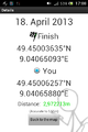
The distance was jumping around a bit
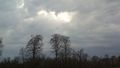
Some hawks fighting in the sky


