Difference between revisions of "2013-04-18 61 24"
From Geohashing
imported>Teukkam ([live picture] No idea what this building is, but VPK stands for voluntary fire brigade. [http://www.openstreetmap.org/?lat=61.45010000&lon=24.03550000&zoom=16&layers=B000FTF @61.4501,24.0355]) |
m |
||
| (2 intermediate revisions by 2 users not shown) | |||
| Line 15: | Line 15: | ||
}} | }} | ||
| − | + | ||
__NOTOC__ | __NOTOC__ | ||
== Location == | == Location == | ||
| − | + | ||
| + | In Kangasala, southwest of lake Kirkkojärvi on a field. | ||
== Participants == | == Participants == | ||
| − | + | ||
| − | + | * [[User:Teukkam|TeukkaM]] | |
== Plans == | == Plans == | ||
| Line 32: | Line 33: | ||
*In Kangasala, southwest of lake Kirkkojärvi on a field. Will ride past the scene to see if the hash is reachable. -- [[User:Teukkam|TeukkaM]] ([[User talk:Teukkam|talk]]) [http://www.openstreetmap.org/?lat=61.44801940&lon=23.83406840&zoom=16&layers=B000FTF @61.4480,23.8341] 08:19, 18 April 2013 (EEST) | *In Kangasala, southwest of lake Kirkkojärvi on a field. Will ride past the scene to see if the hash is reachable. -- [[User:Teukkam|TeukkaM]] ([[User talk:Teukkam|talk]]) [http://www.openstreetmap.org/?lat=61.44801940&lon=23.83406840&zoom=16&layers=B000FTF @61.4480,23.8341] 08:19, 18 April 2013 (EEST) | ||
| + | |||
| + | |||
== Tracklog == | == Tracklog == | ||
<!-- if your GPS device keeps a log, you may post a link here --> | <!-- if your GPS device keeps a log, you may post a link here --> | ||
| Line 56: | Line 59: | ||
<!-- Add any achievement ribbons you earned below, or remove this section --> | <!-- Add any achievement ribbons you earned below, or remove this section --> | ||
| + | * Land Geohash?? | ||
| − | |||
| − | |||
| − | |||
| − | + | [[Category:Expeditions]] | |
| − | |||
| − | [[Category: | ||
| − | |||
| − | |||
| − | |||
| − | |||
[[Category:Expeditions with photos]] | [[Category:Expeditions with photos]] | ||
[[Category:Expeditions with videos]] | [[Category:Expeditions with videos]] | ||
| − | |||
| − | |||
| − | |||
| − | |||
| − | |||
| − | |||
| − | |||
[[Category:Coordinates not reached]] | [[Category:Coordinates not reached]] | ||
| − | |||
| − | |||
| − | |||
| − | |||
| − | |||
[[Category:Not reached - No public access]] | [[Category:Not reached - No public access]] | ||
| − | + | {{location|FI|11}} | |
| − | |||
| − | |||
| − | |||
| − | |||
| − | |||
| − | |||
| − | |||
Latest revision as of 11:43, 9 April 2022
| Thu 18 Apr 2013 in 61,24: 61.4500363, 24.0406509 geohashing.info google osm bing/os kml crox |
Location
In Kangasala, southwest of lake Kirkkojärvi on a field.
Participants
Plans
Expedition
- In Kangasala, southwest of lake Kirkkojärvi on a field. Will ride past the scene to see if the hash is reachable. -- TeukkaM (talk) @61.4480,23.8341 08:19, 18 April 2013 (EEST)
Tracklog
Photos
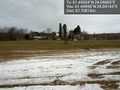
"Nature path" @61.4457,24.0430
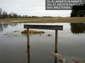
Some kind of small chapel in the woods. Unfortunately the road to there was flooded. @61.4460,24.0430
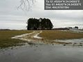
Hash point located at the center of picture @61.4496,24.0414
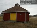
No idea what this building is, but VPK stands for voluntary fire brigade. @61.4501,24.0355


Achievements
- Land Geohash??