Difference between revisions of "2013-04-19 43 -116"
imported>Eldin ([live picture] And the sign beside the road.) |
imported>Eldin (fill in expedition details.) |
||
| Line 1: | Line 1: | ||
| − | |||
| − | |||
| − | |||
| − | |||
| − | |||
| − | |||
| − | |||
| − | |||
| − | |||
| − | |||
{{meetup graticule | {{meetup graticule | ||
| lat=43 | | lat=43 | ||
| Line 15: | Line 5: | ||
}} | }} | ||
| − | |||
__NOTOC__ | __NOTOC__ | ||
== Location == | == Location == | ||
| − | + | ||
| + | In the desert about 10 miles south of the Boise airport. | ||
== Participants == | == Participants == | ||
| − | + | ||
| − | + | * [[User:Eldin|Eldin]] | |
| + | * Pojana | ||
== Plans == | == Plans == | ||
| − | + | ||
| + | The hash looked like it should be reachable, and I didn't have anything better to do after work. | ||
== Expedition == | == Expedition == | ||
| − | + | My wife and I set out towards the hash a bit before 7pm. It had been raining much of the day, but the rain had stopped at that time. The trip was generally uneventful, except that we ran out of pavement about 7 miles sooner than I had expected to. | |
| + | |||
| + | About 5 miles from the hash, we passed a sign indicating that the area was used by the national guard for training exercises, and warning civilians to stay out of areas where exercises were in progress. This didn't worry us much, as such training exercises don't go on all the time. And besides, the area is hundreds of square miles. Even if they are training today, what are the odds that it's in the area of the hash? | ||
| + | |||
| + | It turns out that either the odds were higher than I would have thought, or we just got particularly unlucky. Because after passing several turn-offs which did not lead to areas with training exercises in progress, we got to the turn that lead to the area of the hash. And it had a sign indicating that military training exercises were in progress. So we got some pictures at that point, and headed back towards home. | ||
| + | On the way home, it started raining again, much harder than it had been raining any time earlier that day, so it might be for the best that we weren't 2 miles down a dirt road at the hashpoint when that happened. | ||
*Failed due to military training exercises. -- [[User:Eldin|Eldin]] ([[User talk:Eldin|talk]]) [http://www.openstreetmap.org/?lat=43.34700195&lon=-116.23445168&zoom=16&layers=B000FTF @43.3470,-116.2345] 19:43, 19 April 2013 (MDT) | *Failed due to military training exercises. -- [[User:Eldin|Eldin]] ([[User talk:Eldin|talk]]) [http://www.openstreetmap.org/?lat=43.34700195&lon=-116.23445168&zoom=16&layers=B000FTF @43.3470,-116.2345] 19:43, 19 April 2013 (MDT) | ||
| − | |||
| − | |||
== Photos == | == Photos == | ||
| − | |||
| − | |||
| − | |||
<gallery perrow="5"> | <gallery perrow="5"> | ||
| Line 48: | Line 40: | ||
== Achievements == | == Achievements == | ||
{{#vardefine:ribbonwidth|800px}} | {{#vardefine:ribbonwidth|800px}} | ||
| − | |||
| + | {{No trespassing | ||
| + | | latitude = 43 | ||
| + | | longitude = -116 | ||
| + | | date = 2013-04-19 | ||
| + | | name = [[User:Eldin|Eldin]] | ||
| + | }} | ||
| − | |||
| − | |||
| − | |||
| − | |||
| − | |||
| − | |||
| − | |||
| − | |||
| − | |||
| − | |||
[[Category:Expeditions]] | [[Category:Expeditions]] | ||
| − | |||
[[Category:Expeditions with photos]] | [[Category:Expeditions with photos]] | ||
| − | |||
| − | |||
| − | |||
| − | |||
| − | |||
| − | |||
| − | |||
| − | |||
| − | |||
[[Category:Coordinates not reached]] | [[Category:Coordinates not reached]] | ||
| − | |||
| − | |||
| − | |||
| − | |||
| − | |||
[[Category:Not reached - No public access]] | [[Category:Not reached - No public access]] | ||
| − | |||
| − | |||
| − | |||
| − | |||
| − | |||
| − | |||
| − | |||
| − | |||
Revision as of 03:57, 20 April 2013
| Fri 19 Apr 2013 in 43,-116: 43.3154750, -116.2787965 geohashing.info google osm bing/os kml crox |
Location
In the desert about 10 miles south of the Boise airport.
Participants
- Eldin
- Pojana
Plans
The hash looked like it should be reachable, and I didn't have anything better to do after work.
Expedition
My wife and I set out towards the hash a bit before 7pm. It had been raining much of the day, but the rain had stopped at that time. The trip was generally uneventful, except that we ran out of pavement about 7 miles sooner than I had expected to.
About 5 miles from the hash, we passed a sign indicating that the area was used by the national guard for training exercises, and warning civilians to stay out of areas where exercises were in progress. This didn't worry us much, as such training exercises don't go on all the time. And besides, the area is hundreds of square miles. Even if they are training today, what are the odds that it's in the area of the hash?
It turns out that either the odds were higher than I would have thought, or we just got particularly unlucky. Because after passing several turn-offs which did not lead to areas with training exercises in progress, we got to the turn that lead to the area of the hash. And it had a sign indicating that military training exercises were in progress. So we got some pictures at that point, and headed back towards home.
On the way home, it started raining again, much harder than it had been raining any time earlier that day, so it might be for the best that we weren't 2 miles down a dirt road at the hashpoint when that happened.
- Failed due to military training exercises. -- Eldin (talk) @43.3470,-116.2345 19:43, 19 April 2013 (MDT)
Photos
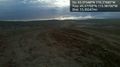
Road that leads near the hash.
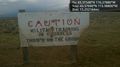
And the sign beside the road.


Achievements
Eldin earned the No trespassing consolation prize
|