Difference between revisions of "2013-04-28 51 5"
From Geohashing
imported>Wythnir (Created page with "{{subst:Expedition |lat = 51 |lon = 5 |date = 2013-04-28 }}") |
imported>Wythnir |
||
| Line 1: | Line 1: | ||
| − | |||
| − | |||
| − | |||
| − | |||
| − | |||
| − | |||
| − | |||
| − | |||
| − | |||
| − | |||
{{meetup graticule | {{meetup graticule | ||
| lat=51 | | lat=51 | ||
| Line 15: | Line 5: | ||
}} | }} | ||
| − | |||
__NOTOC__ | __NOTOC__ | ||
== Location == | == Location == | ||
| − | + | In the bushes next to a small road near Schaft. | |
== Participants == | == Participants == | ||
| − | + | [[User:Wythnir|Wythnir]] | |
| − | |||
| − | |||
| − | |||
| − | |||
== Expedition == | == Expedition == | ||
| − | + | The location was about 15 km from my home, so I decided to go by bike, dragging my dad along for the ride. It was a nice day with little wind. The hash was near a small road. We went home over a longer, but more scenic road. | |
| − | |||
| − | |||
| − | |||
== Photos == | == Photos == | ||
| Line 38: | Line 20: | ||
--> | --> | ||
<gallery perrow="5"> | <gallery perrow="5"> | ||
| + | Image:20130428515 gps.png | 3m from hash | ||
| + | Image:20130428515 marker.jpg | xkcd marker | ||
| + | Image:20130428515 ponies.jpg | nearby ponies and a goose | ||
</gallery> | </gallery> | ||
== Achievements == | == Achievements == | ||
{{#vardefine:ribbonwidth|800px}} | {{#vardefine:ribbonwidth|800px}} | ||
| − | + | {{land geohash | latitude = 51 | longitude = 5 | date = 2013-04-28 | name = Wythnir }} | |
| + | {{Bicycle geohash | latitude = 51 | longitude = 5 | date = 2013-04-28 | name = Wythnir }} | ||
| + | {{drag-along | latitude = 51 | longitude = 5 | date = 2013-04-28 | name = Wythnir }} | ||
<!-- =============== USEFUL CATEGORIES FOLLOW ================ | <!-- =============== USEFUL CATEGORIES FOLLOW ================ | ||
| − | |||
| − | |||
| − | |||
| − | |||
| − | |||
| − | |||
| − | |||
| − | |||
| − | |||
[[Category:Expeditions]] | [[Category:Expeditions]] | ||
| − | + | [[Category:Expeditions with photos]] | |
| − | [[Category:Expeditions with photos]] | ||
| − | |||
| − | |||
| − | |||
| − | |||
| − | |||
[[Category:Coordinates reached]] | [[Category:Coordinates reached]] | ||
| − | |||
| − | |||
| − | |||
| − | |||
| − | |||
| − | |||
| − | |||
| − | |||
| − | |||
| − | |||
| − | |||
| − | |||
| − | |||
| − | |||
| − | |||
| − | |||
| − | |||
| − | |||
Revision as of 15:33, 28 April 2013
| Sun 28 Apr 2013 in 51,5: 51.2958254, 5.4715725 geohashing.info google osm bing/os kml crox |
Location
In the bushes next to a small road near Schaft.
Participants
Expedition
The location was about 15 km from my home, so I decided to go by bike, dragging my dad along for the ride. It was a nice day with little wind. The hash was near a small road. We went home over a longer, but more scenic road.
Photos
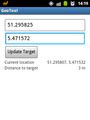
3m from hash
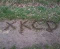
xkcd marker
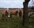
nearby ponies and a goose


Achievements
Wythnir earned the Land geohash achievement
|
Wythnir earned the Bicycle geohash achievement
|
Wythnir earned the Drag-along achievement
|