Difference between revisions of "2013-04-29 39 -105"
From Geohashing
imported>Sylae (Created page with "{{meetup graticule | lat=39 | lon=-105 | date=2013-04-29 }} == Location == Private Land, just outside Roxborough State Park == Participants == *Sylae...") |
m |
||
| (2 intermediate revisions by 2 users not shown) | |||
| Line 23: | Line 23: | ||
== Photos == | == Photos == | ||
| − | < | + | <gallery> |
| + | File:2013-04-29 39 -105 sylae closest approach.jpg | Coordinates at the locked gate | ||
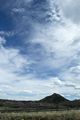
| + | File:2013-04-29 39 -105 sylae wildcat mountain.jpg | Wildcat mountain | ||
| + | </gallery> | ||
== Achievements == | == Achievements == | ||
| Line 33: | Line 36: | ||
[[Category:Expeditions with photos]] | [[Category:Expeditions with photos]] | ||
[[Category:Coordinates not reached]] | [[Category:Coordinates not reached]] | ||
| + | [[Category:Not reached - No public access]] | ||
| + | {{location|US|CO|DU}} | ||
Latest revision as of 10:28, 16 March 2022
| Mon 29 Apr 2013 in 39,-105: 39.4161675, -105.0492301 geohashing.info google osm bing/os kml crox |
Location
Private Land, just outside Roxborough State Park
Participants
Plans
Plan was to leave Denver via I-25, Pull off at Happy Canyon Road, then take US 85 to State 67. After that, simply taking Rainbow Creek Road all the way up to it.
Expedition
Everything went as planned, until hitting a locked gate a little over a mile away. Got some neat pictures of nearby Wildcat Mountain, though. Also notable is the fact that 7.5' quad maps are really useless when you scale them down to fit on a piece of letter paper, so I was unable to plot an alternate route to the geohash, and had to head home. I might try and hit another graticule tonight though, the day is still young!
Photos
Coordinates at the locked gate
Wildcat mountain


Achievements
Sylae (talk) earned the No trespassing consolation prize
|