Difference between revisions of "2013-05-20 48 7"
imported>Hijackal ([live picture] Hijackal enjoying flapjacks at hash. [http://www.openstreetmap.org/?lat=48.05470000&lon=7.78811000&zoom=16&layers=B000FTF @48.0547,7.7881]) |
imported>Flopp |
||
| Line 32: | Line 32: | ||
{{land geohash | latitude = 48 | longitude = 7 | date = 2013-05-20 | name = [[user:Flopp|Flopp]]}} | {{land geohash | latitude = 48 | longitude = 7 | date = 2013-05-20 | name = [[user:Flopp|Flopp]]}} | ||
{{Bicycle geohash | latitude = 48 | longitude = 7 | date = 2013-05-20 | name = [[User:Flopp|Flopp]] | distance = ~15 km }} | {{Bicycle geohash | latitude = 48 | longitude = 7 | date = 2013-05-20 | name = [[User:Flopp|Flopp]] | distance = ~15 km }} | ||
| + | {{Earliest geohasher | latitude = 48 | longitude = 7 | date = 2013-05-20 | name = [[User:Flopp|Flopp]] }} | ||
Revision as of 12:49, 20 May 2013
| Mon 20 May 2013 in 48,7: 48.0547253, 7.7881194 geohashing.info google osm bing/os kml crox |
Location
On a Field near March, North of Freiburg
Participants
Expedition by Flopp
Visited the hashpoint by bike and before breakfast. Since it was Pentecost Monday (a public holiday in Germany), the roads were quiet and I only met a few people.
The main motivation for approaching this geohash was to fulfill the logging requirements of a [virtual geocache].
Photos by Flopp
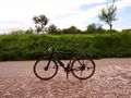
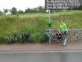
Flopp's bike
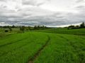
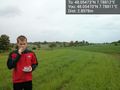
Landscape at the hash
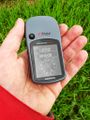
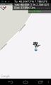
Flopp's GPS
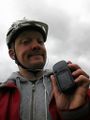
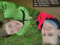
Flopp's stupid grin


Achievements by Flopp
Flopp earned the Land geohash achievement
|
Flopp earned the Bicycle geohash achievement
|
Flopp earned the Earliest geohasher achievement
|
Plans
The weather forecast isn't very good, but this one is too close to miss for Frizzy and Hijackal. They will be there at about noon.
Expedition
Tracklog
Photos
Frizzy-nav decides this lantern is close enough to dismount. @48.0550,7.7877
Proof of reachedness. @48.0547,7.7881
Hashpoint. Snack. Hashers collaborating to operate phone. Rain not shown. @48.0547,7.7881
Hijackal enjoying flapjacks at hash. @48.0547,7.7881


Achievements