Difference between revisions of "2013-05-20 52 5"
imported>Eupeodes (→Expedition) |
imported>FippeBot m (Location) |
||
| (8 intermediate revisions by 2 users not shown) | |||
| Line 15: | Line 15: | ||
}} | }} | ||
| − | + | ||
__NOTOC__ | __NOTOC__ | ||
== Location == | == Location == | ||
| − | + | ||
Google shows it to be on the edge of a forest near a track in Planken Wambuis on the Veluwe | Google shows it to be on the edge of a forest near a track in Planken Wambuis on the Veluwe | ||
== Participants == | == Participants == | ||
| − | + | ||
| − | + | * [[User:Eupeodes|Eupeodes]] | |
| − | [[User:Eupeodes|Eupeodes]] | ||
== Plans == | == Plans == | ||
| − | + | ||
Cycle there, visit a geocache on the way there, visit the hash, go home and do all that by bike in perfect tron. | Cycle there, visit a geocache on the way there, visit the hash, go home and do all that by bike in perfect tron. | ||
== Expedition == | == Expedition == | ||
| − | + | ||
| − | Left home end of the morning. The cache [http://coord.info/GC11Z54 Two worlds] was found quickly, I hoped the hash would be just as easy, but it wasn't. When approaching from the southeast I found a sign telling me the area behind was a resting area for wild animals. So I tried to cycle around the area and reach the other side. The other side was not better | + | Left home end of the morning. The cache [http://coord.info/GC11Z54 Two worlds] was found quickly, I hoped the hash would be just as easy, but it wasn't. |
| + | |||
| + | When approaching from the southeast I found a sign telling me the area behind was a resting area for wild animals. So I tried to cycle around the area and reach the other side. The other side was not better: not only was a fence | ||
| + | now added to make the message even stronger, but also the surface turned to loose sand, not convenient to walk through with a bike. | ||
| + | |||
| + | When I found a road again I still had the edge of the resting area directly left of me. The road followed the edge perfectly and after some more cycling I ended up on the same spot I had been before. So I did ride a circle around the hash, but it was not reachable. After this disappointment I failed one geocache and found 5 more before I reached home again. | ||
== Tracklog == | == Tracklog == | ||
| − | + | ||
| + | Below is a picture of my track around the closed area and the hash | ||
| + | |||
| + | [[File:2013-05-20_52_5_the_area.jpg]] | ||
== Photos == | == Photos == | ||
| − | + | ||
| − | |||
| − | |||
<gallery perrow="5"> | <gallery perrow="5"> | ||
| + | Image:2013-05-20_52_5_welcome.jpg | Welcome in the area | ||
| + | Image:2013-05-20_52_5_bike.jpg | My bike | ||
| + | Image:2013-05-20_52_5_not_welcome.jpg | Stay out | ||
| + | Image:2013-05-20_52_5_euh.jpg | Over there... | ||
</gallery> | </gallery> | ||
== Achievements == | == Achievements == | ||
{{#vardefine:ribbonwidth|800px}} | {{#vardefine:ribbonwidth|800px}} | ||
| − | + | {{No trespassing |latitude=52 |longitude=5 |date=2013-05-20 |image=2013-05-20_52_5_euh.jpg |name= [[User:Eupeodes|Eupeodes]] |distance=less than one kilometer }} | |
| − | |||
| − | |||
| − | |||
| − | |||
| − | |||
| − | |||
| − | |||
| − | |||
| − | [[ | ||
| − | |||
| − | |||
[[Category:Expeditions]] | [[Category:Expeditions]] | ||
| − | |||
[[Category:Expeditions with photos]] | [[Category:Expeditions with photos]] | ||
| − | |||
| − | |||
| − | |||
| − | |||
| − | |||
| − | |||
| − | |||
| − | |||
| − | |||
[[Category:Coordinates not reached]] | [[Category:Coordinates not reached]] | ||
| − | |||
| − | |||
| − | |||
| − | |||
| − | |||
[[Category:Not reached - No public access]] | [[Category:Not reached - No public access]] | ||
| − | + | [[Category:Eupeodes]] | |
| − | + | {{location|NL|GE}} | |
| − | [[Category: | ||
| − | |||
| − | |||
| − | |||
| − | |||
| − | |||
Latest revision as of 02:26, 14 August 2019
| Mon 20 May 2013 in 52,5: 52.0547253, 5.7881194 geohashing.info google osm bing/os kml crox |
Location
Google shows it to be on the edge of a forest near a track in Planken Wambuis on the Veluwe
Participants
Plans
Cycle there, visit a geocache on the way there, visit the hash, go home and do all that by bike in perfect tron.
Expedition
Left home end of the morning. The cache Two worlds was found quickly, I hoped the hash would be just as easy, but it wasn't.
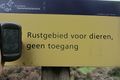
When approaching from the southeast I found a sign telling me the area behind was a resting area for wild animals. So I tried to cycle around the area and reach the other side. The other side was not better: not only was a fence now added to make the message even stronger, but also the surface turned to loose sand, not convenient to walk through with a bike.
When I found a road again I still had the edge of the resting area directly left of me. The road followed the edge perfectly and after some more cycling I ended up on the same spot I had been before. So I did ride a circle around the hash, but it was not reachable. After this disappointment I failed one geocache and found 5 more before I reached home again.
Tracklog
Below is a picture of my track around the closed area and the hash

Photos

Welcome in the area
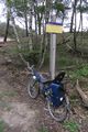
My bike

Stay out
Over there...


Achievements
Eupeodes earned the No trespassing consolation prize
|