Difference between revisions of "2013-05-22 43 -89"
From Geohashing
imported>Swensonj m (→Expedition: win) |
imported>Swensonj (pictures!) |
||
| Line 1: | Line 1: | ||
| − | + | [[Image:{{{image|2013-05-22 43 -89 Track.JPG}}}|thumb|left|picture of tracklog]] | |
| − | |||
| − | [[Image:{{{image| | ||
| − | |||
| − | |||
| − | |||
| − | |||
| − | |||
| − | |||
{{meetup graticule | {{meetup graticule | ||
| lat=43 | | lat=43 | ||
| Line 28: | Line 20: | ||
Success! More soon.... | Success! More soon.... | ||
| − | |||
| − | |||
| − | |||
== Photos == | == Photos == | ||
| Line 36: | Line 25: | ||
Image:2012-##-## ## ## Alpha.jpg | Witty Comment | Image:2012-##-## ## ## Alpha.jpg | Witty Comment | ||
--> | --> | ||
| − | <gallery perrow=" | + | <gallery perrow="4"> |
| + | Image:2013-05-22 43 -89 Garden.jpg | An attractive garden on Pike's Peak Road | ||
| + | Image:2013-05-22 43 -89 Mower.jpg | Home-built bicycle lawnmower at the trailhead | ||
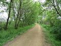
| + | Image:2013-05-22 43 -89 Trailhead.jpg | View from the parking place | ||
| + | Image:2013-05-22 43 -89 Sign.jpg | A day-use pass is required | ||
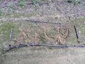
| + | Image:2013-05-22 43 -89 Proof.jpg | proof photo of recalcitrant GPS | ||
| + | Image:2013-05-22 43 -89 Grin.jpg | I was there! | ||
| + | Image:2013-05-22 43 -89 Hash.jpg | Military Ridge State Trail | ||
| + | Image:2013-05-22 43 -89 Marker.jpg | XKCD marker | ||
| + | Image:2013-05-22 43 -89 Circus.jpg | Exhibition of circus-related skill | ||
| + | Image:2013-05-22 43 -89 Violet.jpg | A single violet near the hashpoint | ||
| + | Image:2013-05-22 43 -89 Squishy.jpg | This Geosquishy was found at a gas station up the highway | ||
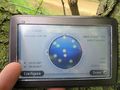
| + | Image:2013-05-22 43 -89 Track.JPG | picture of the tracklog | ||
</gallery> | </gallery> | ||
| Line 45: | Line 46: | ||
<!-- =============== USEFUL CATEGORIES FOLLOW ================ | <!-- =============== USEFUL CATEGORIES FOLLOW ================ | ||
| − | |||
| − | |||
| − | |||
[[Category:Expeditions]] | [[Category:Expeditions]] | ||
| − | |||
[[Category:Expeditions with photos]] | [[Category:Expeditions with photos]] | ||
| − | |||
| − | |||
| − | |||
| − | |||
| − | |||
[[Category:Coordinates reached]] | [[Category:Coordinates reached]] | ||
| − | |||
| − | |||
| − | |||
| − | |||
| − | |||
| − | |||
| − | |||
| − | |||
| − | |||
| − | |||
| − | |||
| − | |||
| − | |||
| − | |||
| − | |||
| − | |||
| − | |||
| − | |||
Revision as of 14:00, 23 May 2013

| Wed 22 May 2013 in 43,-89: 43.0122519, -89.9546343 geohashing.info google osm bing/os kml crox |
Location
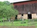
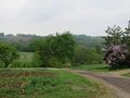
Military Ridge State Trail, near Hwy 151 at Pikes Peak Road, west of Barneveld, Wisconsin.
Participants
Plans
I (SwensonJ) hope to hit this around lunchtime. Very accessible, and about as close to my house as you can be in 43,-89!
Expedition
Success! More soon....
Photos
An attractive garden on Pike's Peak Road
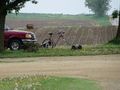
Home-built bicycle lawnmower at the trailhead
View from the parking place
A day-use pass is required
proof photo of recalcitrant GPS

I was there!
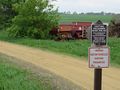
Military Ridge State Trail
XKCD marker
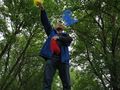
Exhibition of circus-related skill
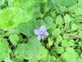
A single violet near the hashpoint

This Geosquishy was found at a gas station up the highway
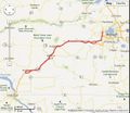
picture of the tracklog


