Difference between revisions of "2013-06-05 49 8"
From Geohashing
imported>Draradech (Created page with "{{subst:Expedition |lat = 49 |lon = 8 |date = 2013-06-05 }}") |
imported>Draradech |
||
| Line 1: | Line 1: | ||
| + | {{Advert | image = 2013-06-05_49_8_no_grin.jpg}} | ||
| + | {{meetup graticule | lat=49 | lon=8 | date=2013-06-05}} | ||
| − | + | __NOTOC__ | |
| − | |||
| − | |||
| − | |||
| − | |||
| − | |||
| − | |||
| − | |||
| − | |||
| − | |||
| − | |||
| − | |||
| − | |||
| − | |||
| − | |||
| − | |||
== Location == | == Location == | ||
| − | + | A very nice spot with different sorts of wild grass and trees. Near Mörfelden-Walldorf. | |
== Participants == | == Participants == | ||
| − | + | [[User:Draradech|Draradech]] | |
| − | |||
== Plans == | == Plans == | ||
| − | + | Do a bike hash after work. | |
== Expedition == | == Expedition == | ||
| − | + | Did a nice long bike tour (42km) after work and found a very nice hash place. Unfortunately it wasn't reachable, the area is fenced in. So close too, just 11m out. | |
| − | |||
| − | |||
| − | |||
== Photos == | == Photos == | ||
| − | < | + | <gallery perrow="6"> |
| − | Image: | + | Image:2013-06-05_49_8_hash.jpg | Very nice place |
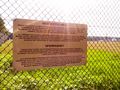
| − | -- | + | Image:2013-06-05_49_8_fail.jpg | But unfortunately, fenced in |
| − | + | Image:2013-06-05_49_8_proof.jpg | Just 11m out | |
| + | Image:2013-06-05_49_8_no_grin.jpg | That's no grin | ||
| + | Image:2013-06-05_49_8_restricted.jpg | 500m from the hash, a much stronger restricted area | ||
| + | Image:2013-06-05_49_8_track.jpg | Track, round the airport | ||
</gallery> | </gallery> | ||
== Achievements == | == Achievements == | ||
{{#vardefine:ribbonwidth|800px}} | {{#vardefine:ribbonwidth|800px}} | ||
| − | + | {{No trespassing | latitude = 49 | longitude = 8 | date = 2013-06-05 | name = [[User:Draradech|Draradech]] | distance = 11m}} | |
| − | |||
| − | |||
| − | |||
| − | |||
| − | |||
| − | |||
| − | |||
| − | |||
| − | |||
| − | |||
| − | |||
[[Category:Expeditions]] | [[Category:Expeditions]] | ||
| − | |||
[[Category:Expeditions with photos]] | [[Category:Expeditions with photos]] | ||
| − | |||
| − | |||
| − | |||
| − | |||
| − | |||
| − | |||
| − | |||
| − | |||
| − | |||
[[Category:Coordinates not reached]] | [[Category:Coordinates not reached]] | ||
| − | |||
| − | |||
| − | |||
| − | |||
| − | |||
[[Category:Not reached - No public access]] | [[Category:Not reached - No public access]] | ||
| − | |||
| − | |||
| − | |||
| − | |||
| − | |||
| − | |||
| − | |||
| − | |||
Revision as of 20:21, 5 June 2013
| Have you seen our geohashing marker? We'd love to hear from you! Click here to say "hi" and tell us what you've seen!
Curious about what geohashing is? Read more! |  |
| Wed 5 Jun 2013 in 49,8: 49.9976606, 8.6127085 geohashing.info google osm bing/os kml crox |
Location
A very nice spot with different sorts of wild grass and trees. Near Mörfelden-Walldorf.
Participants
Plans
Do a bike hash after work.
Expedition
Did a nice long bike tour (42km) after work and found a very nice hash place. Unfortunately it wasn't reachable, the area is fenced in. So close too, just 11m out.
Photos
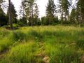
Very nice place
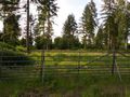
But unfortunately, fenced in
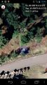
Just 11m out
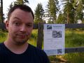
That's no grin
500m from the hash, a much stronger restricted area
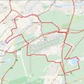
Track, round the airport


Achievements
Draradech earned the No trespassing consolation prize
|