Difference between revisions of "2013-07-13 52 -0"
imported>Nickholden ([live picture] Admit one. But I'm still Mother Nature's bitch. [http://www.openstreetmap.org/?lat=52.58020000&lon=-1.10221000&zoom=16&layers=B000FTF @52.5802,-1.1022]) |
imported>Nickholden (→Tracklog) |
||
| Line 37: | Line 37: | ||
== Tracklog == | == Tracklog == | ||
<!-- if your GPS device keeps a log, you may post a link here --> | <!-- if your GPS device keeps a log, you may post a link here --> | ||
| + | |||
| + | http://app.strava.com/activities/66806675 | ||
== Photos == | == Photos == | ||
Revision as of 19:28, 13 July 2013
| Sat 13 Jul 2013 in 52,-0: 52.6464569, -0.6879201 geohashing.info google osm bing/os kml crox |
Location
In the bird watching / nature reserve at Rutland Water, near Egleton village. I *think* there is public access, or rather access on payment of an admission charge, and I *think* the hashpoint is reachable, at least on foot, if not bicycle.
Participants
Nickholden
All being well, I will cycle over from Leicester, aiming to arrive around 2pm.
Plans
As above, I'll cycle over from Leicester, and pay my admission, and see how close I can get.
Expedition
As it's already 12.10 and I haven't left yet, I expect 2pm might be a little optimistic... ;)
Tracklog
http://app.strava.com/activities/66806675
Photos
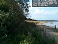
In there somewhere, where the birds are protected, was the hash point. @52.6460,-.6879
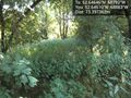
From the other side, still no way to reach it. @52.6461,-.6888
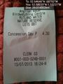
Admit one. But I'm still Mother Nature's bitch. @52.5802,-1.1022


Achievements