Difference between revisions of "2013-07-20 33 -117"
From Geohashing
imported>Svesterli (→Expedition) |
imported>Svesterli (→Photos) |
||
| Line 40: | Line 40: | ||
--> | --> | ||
<gallery perrow="5"> | <gallery perrow="5"> | ||
| + | Image:2013-07-20_33_-117_1.jpg | No Trespassing | ||
| + | Image:2013-07-20_33_-117_2.jpg | The closest I got | ||
</gallery> | </gallery> | ||
Revision as of 10:32, 3 September 2013
| Sat 20 Jul 2013 in 33,-117: 33.1243548, -117.1804745 geohashing.info google osm bing/os kml crox |
Location
San Marcos near Discovery Lake in some brush between a paved trail and an equestrian trail.
Participants
Plans
I would like to go but I am not available until after 6PM. Stephen Cerruti (talk) 10:07, 20 July 2013 (EDT)
Looks fairly easy. Will attempt sometime during the day (but not at 4pm) Sten Vesterli
Expedition
Took a short detour from the freeway while driving from LA to San Diego. Spot was unfortunately in a fenced-off area.
Tracklog
Photos

No Trespassing
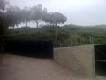
The closest I got


Achievements