Difference between revisions of "2013-08-23 47 0"
imported>Dunaril (→Expedition) |
imported>FippeBot m (Location) |
||
| (3 intermediate revisions by one other user not shown) | |||
| Line 1: | Line 1: | ||
| + | [[Image:{{{image|2013-08-23_47_0_21-13-36-692.jpg}}}|thumb|left]] | ||
| − | |||
| − | |||
| − | |||
| − | |||
| − | |||
| − | |||
| − | |||
| − | |||
| − | |||
{{meetup graticule | {{meetup graticule | ||
| lat=47 | | lat=47 | ||
| Line 18: | Line 10: | ||
== Location == | == Location == | ||
| − | Inside a little forest north of Amboise and the Loire river. | + | Inside a little forest in Montreuil-en-Touraine, north of Amboise and the Loire river. |
== Participants == | == Participants == | ||
| Line 30: | Line 22: | ||
== Expedition == | == Expedition == | ||
| − | + | After our successful first expedition of the day, we still had some advance over most of our friends reaching for the same final destination. So we could totally try our luck at the next planned geohash, which was only 5km out of our way. | |
| + | |||
| + | The sun was setting and luminosity was going down rapidly when we left the A10 and headed south towards Amboise, then turned right to target the geohash and make the GPS scream. Following small roads for a few kilometers we arrived at the "Bois des Landes", a small forest containing the hash, and turned right onto a rocky path that was barely suited for cars. | ||
| + | |||
| + | Sadly we soon arrived at the location of a pedestrian-only path we had planned to follow, only to find a fence enclosing it and likely surrounding the whole end of the forest, and keeping us from reaching the geohash. With the sun setting and time running out, we gave up the idea of going all around the fence to see whether we still had a chance to get to the holy coordinate, so we painfully turned the car back and went back to the road. | ||
| + | |||
| + | All in all it was a fun geohashing journey, and it made our overall trip seem much shorter :) | ||
== Photos == | == Photos == | ||
| − | |||
| − | |||
| − | |||
<gallery perrow="5"> | <gallery perrow="5"> | ||
Image:2013-08-23_47_0_21-13-36-692.jpg | Fail [http://www.openstreetmap.org/?lat=47.45940000&lon=.95125900&zoom=16&layers=B000FTF @47.4594,.9513] | Image:2013-08-23_47_0_21-13-36-692.jpg | Fail [http://www.openstreetmap.org/?lat=47.45940000&lon=.95125900&zoom=16&layers=B000FTF @47.4594,.9513] | ||
</gallery> | </gallery> | ||
| − | |||
== Achievements == | == Achievements == | ||
{{#vardefine:ribbonwidth|800px}} | {{#vardefine:ribbonwidth|800px}} | ||
| − | + | {{No trespassing | latitude = 47 | longitude = 0 | date = 2013-08-23 | name = [[User:Dunaril|Dunaril]] and [[User:Katu|Katu]]}} | |
[[Category:Expeditions]] | [[Category:Expeditions]] | ||
| Line 50: | Line 44: | ||
[[Category:Coordinates not reached]] | [[Category:Coordinates not reached]] | ||
[[Category:Not reached - No public access]] | [[Category:Not reached - No public access]] | ||
| + | {{location|FR|37}} | ||
Latest revision as of 06:23, 6 August 2019

| Fri 23 Aug 2013 in 47,0: 47.4573643, 0.9493154 geohashing.info google osm bing/os kml crox |
Location
Inside a little forest in Montreuil-en-Touraine, north of Amboise and the Loire river.
Participants
Plans
We are driving from Paris to around Amboise in the evening, and this is the second geohash that's close to our planned course. We'll try to reach it if it's not too late and dark already.
Expedition
After our successful first expedition of the day, we still had some advance over most of our friends reaching for the same final destination. So we could totally try our luck at the next planned geohash, which was only 5km out of our way.
The sun was setting and luminosity was going down rapidly when we left the A10 and headed south towards Amboise, then turned right to target the geohash and make the GPS scream. Following small roads for a few kilometers we arrived at the "Bois des Landes", a small forest containing the hash, and turned right onto a rocky path that was barely suited for cars.
Sadly we soon arrived at the location of a pedestrian-only path we had planned to follow, only to find a fence enclosing it and likely surrounding the whole end of the forest, and keeping us from reaching the geohash. With the sun setting and time running out, we gave up the idea of going all around the fence to see whether we still had a chance to get to the holy coordinate, so we painfully turned the car back and went back to the road.
All in all it was a fun geohashing journey, and it made our overall trip seem much shorter :)
Photos
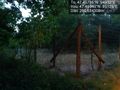
Fail @47.4594,.9513
Achievements
Dunaril and Katu earned the No trespassing consolation prize
|