Difference between revisions of "2013-08-25 44 -123"
From Geohashing
imported>Taper (→Location) |
imported>Taper (→Participants) |
||
| Line 24: | Line 24: | ||
<!-- who attended: If you link to your wiki user name in this section, your expedition will be picked up by the various statistics generated for geohashing. You may use three tildes ~ as a shortcut to automatically insert the user signature of the account you are editing with. | <!-- who attended: If you link to your wiki user name in this section, your expedition will be picked up by the various statistics generated for geohashing. You may use three tildes ~ as a shortcut to automatically insert the user signature of the account you are editing with. | ||
--> | --> | ||
| + | [[User:Taper|Taper]] ([[User talk:Taper|talk]]) | ||
== Plans == | == Plans == | ||
Revision as of 03:19, 26 August 2013
| Sun 25 Aug 2013 in 44,-123: 44.0516226, -123.1574757 geohashing.info google osm bing/os kml crox |
Location
The West Eugene Wetlands, in Eugene, Oregon.
Participants
Plans
Expedition
Tracklog
Photos

Woo, hash in the rain. @44.0516,-123.1580
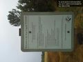
Ah, public land, and the hash point was almost directly on the trail.
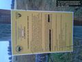
I missed this other sign going in, though. Um... oops? @44.0504,-123.1580


Achievements