Difference between revisions of "2013-08-25 44 -123"
imported>Taper (→Plans) |
imported>Taper (→Expedition) |
||
| Line 32: | Line 32: | ||
== Expedition == | == Expedition == | ||
<!-- how it all turned out. your narrative goes here. --> | <!-- how it all turned out. your narrative goes here. --> | ||
| + | There was torrential rain when I left my house, but I decided to press forward anyway. The satellite map for the hash (I use the android app) seemed pretty straightforward -- it was in a field of some sort out in West Eugene, along a straight trail leading from the road. So, I drove out to the trailhead, arriving about 6:45 PM. There was a gate right there, and a sign proclaiming the field to be the West Eugene Wetlands. The rain had slowed slightly. I stepped through the open pedestrian passage and followed the trail for about 500 feet, checking the GPS reading on my phone only sporadically so it wouldn't get rained on too much. And there I was! Or at least the app said so, due to the margin of error of GPS reception. Huzzah! I took some pictures, and walked back. It was then that I noticed the red barrier tape that had been torn down and was lying around the gate, and the second sign -- which declared that the West Eugene Wetlands was closed to public access through August 29. Um. Oops. Oh, well, no harm, no foul. | ||
== Tracklog == | == Tracklog == | ||
Revision as of 03:44, 26 August 2013
| Sun 25 Aug 2013 in 44,-123: 44.0516226, -123.1574757 geohashing.info google osm bing/os kml crox |
Location
The West Eugene Wetlands, in Eugene, Oregon.
Participants
Plans
I saw Friday that the hashes for Saturday and Sunday were relatively close to/in town, so decided to try for them; Saturday's expedition was called off when my phone/GPS battery died during journey preparations. "Sunday or bust!" I vowed. Well, no, not really.
Expedition
There was torrential rain when I left my house, but I decided to press forward anyway. The satellite map for the hash (I use the android app) seemed pretty straightforward -- it was in a field of some sort out in West Eugene, along a straight trail leading from the road. So, I drove out to the trailhead, arriving about 6:45 PM. There was a gate right there, and a sign proclaiming the field to be the West Eugene Wetlands. The rain had slowed slightly. I stepped through the open pedestrian passage and followed the trail for about 500 feet, checking the GPS reading on my phone only sporadically so it wouldn't get rained on too much. And there I was! Or at least the app said so, due to the margin of error of GPS reception. Huzzah! I took some pictures, and walked back. It was then that I noticed the red barrier tape that had been torn down and was lying around the gate, and the second sign -- which declared that the West Eugene Wetlands was closed to public access through August 29. Um. Oops. Oh, well, no harm, no foul.
Tracklog
Photos

Woo, hash in the rain. @44.0516,-123.1580
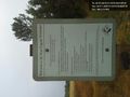
Ah, public land, and the hash point was almost directly on the trail.
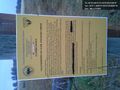
I missed this other sign going in, though. Um... oops? @44.0504,-123.1580


Achievements