Difference between revisions of "2013-09-13 40 -74"
From Geohashing
imported>Jevanyn ([live picture] Closest intersection, plus a silly face [http://www.openstreetmap.org/?lat=40.47320050&lon=-74.87837229&zoom=16&layers=B000FTF @40.4732,-74.8784]) |
imported>Jevanyn ([live] Closest approach is here, inside the margin of error. Long time no geohash, nice to have a chance to do this again :-)) |
||
| Line 30: | Line 30: | ||
<!-- how it all turned out. your narrative goes here. --> | <!-- how it all turned out. your narrative goes here. --> | ||
| + | |||
| + | *Closest approach is here, inside the margin of error. Long time no geohash, nice to have a chance to do this again :-) -- [[User:Jevanyn|Jevanyn]] ([[User talk:Jevanyn|talk]]) [http://www.openstreetmap.org/?lat=40.47317812&lon=-74.87726932&zoom=16&layers=B000FTF @40.4732,-74.8773] 13:55, 13 September 2013 (EDT) | ||
== Tracklog == | == Tracklog == | ||
<!-- if your GPS device keeps a log, you may post a link here --> | <!-- if your GPS device keeps a log, you may post a link here --> | ||
Revision as of 17:55, 13 September 2013
| Fri 13 Sep 2013 in 40,-74: 40.4731319, -74.8772739 geohashing.info google osm bing/os kml crox |
Location
Participants
Plans
Expedition
- Closest approach is here, inside the margin of error. Long time no geohash, nice to have a chance to do this again :-) -- Jevanyn (talk) @40.4732,-74.8773 13:55, 13 September 2013 (EDT)
Tracklog
Photos
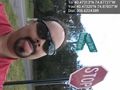
Closest intersection, plus a silly face @40.4732,-74.8784

Achievements