Difference between revisions of "2013-09-22 55 37"
From Geohashing
imported>Vb (An expedition message sent via Geohash Droid for Android.) |
imported>FippeBot m (Location) |
||
| (9 intermediate revisions by one other user not shown) | |||
| Line 19: | Line 19: | ||
== Location == | == Location == | ||
<!-- where you've surveyed the hash to be --> | <!-- where you've surveyed the hash to be --> | ||
| + | |||
| + | At the side of Moscow Ring Road, west. | ||
== Participants == | == Participants == | ||
| Line 24: | Line 26: | ||
--> | --> | ||
| − | + | * [[User:Vb|vb]] | |
| − | + | ||
== Expedition == | == Expedition == | ||
<!-- how it all turned out. your narrative goes here. --> | <!-- how it all turned out. your narrative goes here. --> | ||
| − | + | Some sort of constriction in progress. No public access. | |
| − | |||
== Photos == | == Photos == | ||
| Line 38: | Line 39: | ||
--> | --> | ||
<gallery perrow="5"> | <gallery perrow="5"> | ||
| + | |||
| + | Image:2013-09-22_55_37_17-14-43-263.jpg | On the way to the hash. [http://www.openstreetmap.org/?lat=55.71520000&lon=37.41840000&zoom=16&layers=B000FTF @55.7152,37.4184] | ||
| + | |||
| + | Image:2013-09-22_55_37_23-30-26-479.jpg | No public access [http://www.openstreetmap.org/?lat=55.72680000&lon=37.37950000&zoom=16&layers=B000FTF @55.7268,37.3795] | ||
| + | |||
| + | Image:2013-09-22_55_37_23-26-50-456.jpg | Across the road [http://www.openstreetmap.org/?lat=55.72760000&lon=37.37830000&zoom=16&layers=B000FTF @55.7276,37.3783] | ||
| + | |||
| + | Image:2013-09-22_55_37_23-30-48-418.jpg | [http://www.openstreetmap.org/?lat=55.72760000&lon=37.37840000&zoom=16&layers=B000FTF @55.7276,37.3784] | ||
| + | |||
| + | Image:2013-09-22_55_37_23-28-16-282.jpg | [http://www.openstreetmap.org/?lat=55.70643269&lon=37.56341012&zoom=16&layers=B000FTF @55.7064,37.5634] | ||
</gallery> | </gallery> | ||
| Line 45: | Line 56: | ||
| − | |||
| − | |||
| − | |||
| − | |||
| − | |||
| − | |||
| − | |||
| − | |||
| − | |||
| − | |||
[[Category:Expeditions]] | [[Category:Expeditions]] | ||
| − | |||
[[Category:Expeditions with photos]] | [[Category:Expeditions with photos]] | ||
| − | |||
| − | |||
| − | |||
| − | |||
| − | |||
| − | |||
| − | |||
| − | |||
| − | |||
[[Category:Coordinates not reached]] | [[Category:Coordinates not reached]] | ||
| − | |||
| − | |||
| − | |||
| − | |||
| − | |||
[[Category:Not reached - No public access]] | [[Category:Not reached - No public access]] | ||
| − | + | [[Category:Public transport geohash achievement]] | |
| − | + | {{location|RU|MOW}} | |
| − | [[Category: | ||
| − | |||
| − | |||
| − | |||
| − | |||
| − | |||
Latest revision as of 04:05, 14 August 2019
| Sun 22 Sep 2013 in 55,37: 55.7277410, 37.3791792 geohashing.info google osm bing/os kml crox |
Location
At the side of Moscow Ring Road, west.
Participants
Expedition
Some sort of constriction in progress. No public access.
Photos
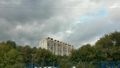
On the way to the hash. @55.7152,37.4184
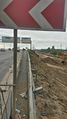
No public access @55.7268,37.3795
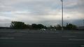
Across the road @55.7276,37.3783


