Difference between revisions of "2013-10-27 42 -91"
imported>Michael5000 m (→Photos) |
imported>Michael5000 m (→Achievements) |
||
| Line 52: | Line 52: | ||
| − | + | ||
| − | |||
[[Category:New report]] | [[Category:New report]] | ||
| − | |||
| − | |||
[[Category:Expedition planning]] | [[Category:Expedition planning]] | ||
| − | |||
<!-- An actual expedition: | <!-- An actual expedition: | ||
Revision as of 02:20, 27 October 2013
| Sun 27 Oct 2013 in 42,-91: 42.7883884, -91.0978016 geohashing.info google osm bing/os kml crox |
Location
On the shore of the Mississippi in Guttenberg, Iowa.
Participants
Plans
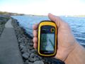
After 2013-10-26 43 -92, I thought I'd stop by Gutterberg to confirm my suspicion that this one would be either in the river or on an inaccessible protected levee. What I discovered is that, along with a lovely riverside park, the town has twin trails at the top and bottom of the levee both. I got down on the lower trail, and voila! was able to stand at the hashpoint about eight hours before it became the hashpoint. Then, just to keep things surreal, a faux old-style Mississippi Riverboat came around the bend and through the nearby locks.
Since the hashpoint is for reals, I poked around town and found a motel. Then I went for a run on the levee trails, crossing the hashpoint again about six hours before it became the hashpoint. At this writing, it is still about three hours until it becomes the hashpoint.
Expedition
Tracklog
Photos
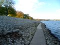
The trail along the bottom of the levee...
...that goes right over the hashpoint-to-be.

Goofy grin fail.
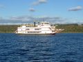
It is the Mississippi, so of course there's a riverboat.
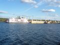
It goes into the locks.
.JPG)
.JPG)
.JPG)
.JPG)
.JPG)
Achievements