Difference between revisions of "2013-11-03 43 -123"
imported>Frogman (→Location) |
imported>FippeBot m (Location) |
||
| (5 intermediate revisions by 2 users not shown) | |||
| Line 24: | Line 24: | ||
<!-- who attended: If you link to your wiki user name in this section, your expedition will be picked up by the various statistics generated for geohashing. You may use three tildes ~ as a shortcut to automatically insert the user signature of the account you are editing with. | <!-- who attended: If you link to your wiki user name in this section, your expedition will be picked up by the various statistics generated for geohashing. You may use three tildes ~ as a shortcut to automatically insert the user signature of the account you are editing with. | ||
--> | --> | ||
| + | *[[User:Frogman|Frogman]] | ||
| + | *[[User:Higgs|Higgs]] | ||
| + | *Scott | ||
== Plans == | == Plans == | ||
<!-- what were the original plans --> | <!-- what were the original plans --> | ||
| + | We decided to try to hit this hashpoint in the early morning so that Frogman could get back by noon to eat brunch with his grandma. | ||
== Expedition == | == Expedition == | ||
| − | + | After a pleasant one-and-a-half hour drive, we found ourselves in the quaint community of Yoncalla, Oregon. We drove through town and out onto a county road looking for our turn-off. It turns out Google Maps has some road names incorrect, as we first went up what was actually Whipple Tree Road, hitting a dead end, before going up what Google Maps thought was Whipple Tree Road, which turned out to be someone's driveway. | |
| + | |||
| + | Right after we stopped driving to continue on foot, the property owner drove up behind us and asked us what we were doing. After explaining our purpose and saying that we thought we were on public road, he politely asked us to leave. We tried to reach the hashpoint from another angle but it was entirely surrounded by private property. Oh, well! | ||
== Tracklog == | == Tracklog == | ||
| Line 39: | Line 45: | ||
--> | --> | ||
<gallery perrow="5"> | <gallery perrow="5"> | ||
| + | Image:2013-11-03 prehash.jpg | Pre Hash Hash | ||
| + | Image:2013-11-03 notress.jpg | Oh that sign... | ||
| + | Image:2013-11-03 whipple.jpg | The actual road | ||
</gallery> | </gallery> | ||
== Achievements == | == Achievements == | ||
{{#vardefine:ribbonwidth|800px}} | {{#vardefine:ribbonwidth|800px}} | ||
| − | |||
| + | {{No trespassing | ||
| + | | latitude = 43 | ||
| + | | longitude = -123 | ||
| + | | date = 2013-11-03 | ||
| + | | name = [[User:Frogman|Frogman]], [[User:Higgs|Higgs]], Scott | ||
| + | | distance = 400 meters | ||
| + | }} | ||
| − | |||
| − | |||
| − | |||
| − | |||
| − | |||
| − | |||
| − | |||
| − | |||
| − | |||
| − | |||
[[Category:Expeditions]] | [[Category:Expeditions]] | ||
| − | |||
[[Category:Expeditions with photos]] | [[Category:Expeditions with photos]] | ||
| − | |||
| − | |||
| − | |||
| − | |||
| − | |||
| − | |||
| − | |||
| − | |||
[[Category:Coordinates not reached]] | [[Category:Coordinates not reached]] | ||
| − | |||
| − | |||
| − | |||
| − | |||
| − | |||
[[Category:Not reached - No public access]] | [[Category:Not reached - No public access]] | ||
| − | + | {{location|US|OR|DO}} | |
| − | |||
| − | |||
| − | |||
| − | |||
| − | |||
| − | |||
| − | |||
Latest revision as of 06:43, 6 August 2019
| Sun 3 Nov 2013 in 43,-123: 43.5701598, -123.3219450 geohashing.info google osm bing/os kml crox |
Location
In a forest near Yoncalla, Oregon.
Participants
Plans
We decided to try to hit this hashpoint in the early morning so that Frogman could get back by noon to eat brunch with his grandma.
Expedition
After a pleasant one-and-a-half hour drive, we found ourselves in the quaint community of Yoncalla, Oregon. We drove through town and out onto a county road looking for our turn-off. It turns out Google Maps has some road names incorrect, as we first went up what was actually Whipple Tree Road, hitting a dead end, before going up what Google Maps thought was Whipple Tree Road, which turned out to be someone's driveway.
Right after we stopped driving to continue on foot, the property owner drove up behind us and asked us what we were doing. After explaining our purpose and saying that we thought we were on public road, he politely asked us to leave. We tried to reach the hashpoint from another angle but it was entirely surrounded by private property. Oh, well!
Tracklog
Photos
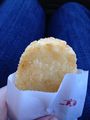
Pre Hash Hash
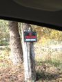
Oh that sign...
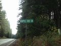
The actual road


Achievements
Frogman, Higgs, Scott earned the No trespassing consolation prize
|