Difference between revisions of "2014-01-02 33 -117"
From Geohashing
imported>Bravissimo594 (All arms and legs. [http://www.openstreetmap.org/?lat=33.97420000&lon=-117.71000000&zoom=16&layers=B000FTF @33.9742,-117.7100]) |
imported>Bravissimo594 (Geohash Droid detail.) |
||
| Line 47: | Line 47: | ||
Image:2014-01-02_33_-117_17-20-42-972.jpg | All arms and legs. [http://www.openstreetmap.org/?lat=33.97420000&lon=-117.71000000&zoom=16&layers=B000FTF @33.9742,-117.7100] | Image:2014-01-02_33_-117_17-20-42-972.jpg | All arms and legs. [http://www.openstreetmap.org/?lat=33.97420000&lon=-117.71000000&zoom=16&layers=B000FTF @33.9742,-117.7100] | ||
| + | |||
| + | Image:2014-01-02_33_-117_17-21-39-600.jpg | Geohash Droid detail. | ||
</gallery> | </gallery> | ||
Revision as of 01:21, 3 January 2014
| Thu 2 Jan 2014 in 33,-117: 33.9741849, -117.7099543 geohashing.info google osm bing/os kml crox |
Location
Roadside at a residential intersection in Chino Hills. Santa Ana graticule.
Participants
Plans
- Bravissimo594 and Boppy5 will be there between 3:45 PM and 4:00. -- Bravissimo594 (talk) 10:21, 2 January 2014 (EST)
Expedition
Tracklog
Photos
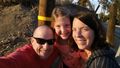
Addi joined us! @33.9742,-117.7100
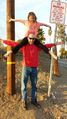
All arms and legs. @33.9742,-117.7100
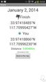
Geohash Droid detail.


Achievements