Difference between revisions of "2014-01-15 54 -2"
From Geohashing
imported>Angel (An expedition message sent via Geohash Droid for Android.) |
imported>FippeBot m (Location) |
||
| (4 intermediate revisions by 2 users not shown) | |||
| Line 30: | Line 30: | ||
<!-- how it all turned out. your narrative goes here. --> | <!-- how it all turned out. your narrative goes here. --> | ||
| + | |||
| + | *11 miles as the cow flies; Google reckons 12 along the Lancaster Canal. I'll be giving this one a try if I wake up at a decent hour tomorrow. -- [[User:Angel|Angel]] ([[User talk:Angel|talk]]) [http://www.openstreetmap.org/?lat=54.03100770&lon=-2.79419096&zoom=16&layers=B000FTF @54.0310,-2.7942] 16:34, 14 January 2014 (EST) | ||
| + | |||
| + | *Hash-hunting is go :) Just stopped for a bacon butty breakfast, and to write my postcards. -- [[User:Angel|Angel]] ([[User talk:Angel|talk]]) [http://www.openstreetmap.org/?lat=54.04857037&lon=-2.79898194&zoom=16&layers=B000FTF @54.0486,-2.7990] 03:57, 15 January 2014 (EST) | ||
== Tracklog == | == Tracklog == | ||
<!-- if your GPS device keeps a log, you may post a link here --> | <!-- if your GPS device keeps a log, you may post a link here --> | ||
| Line 38: | Line 42: | ||
--> | --> | ||
<gallery perrow="5"> | <gallery perrow="5"> | ||
| + | |||
| + | Image:2014-01-15_54_-2_15-16-57-262.jpg | Wasn't quite sure on google view if that was a little park, or someone's garden. Turns out to belong to "The Old Vicarage", which is for sale and contains nobody to ask for permission :( | ||
| + | Hash failed, best distance reached 209 feet [http://www.openstreetmap.org/?lat=54.18348528&lon=-2.72017122&zoom=16&layers=B000FTF @54.1835,-2.7202] | ||
</gallery> | </gallery> | ||
| Line 45: | Line 52: | ||
| − | |||
| − | |||
| − | |||
| − | |||
| − | |||
| − | |||
| − | |||
| − | |||
| − | |||
| − | |||
[[Category:Expeditions]] | [[Category:Expeditions]] | ||
| − | |||
| − | |||
| − | |||
| − | |||
| − | |||
| − | |||
| − | |||
| − | |||
| − | |||
| − | |||
| − | |||
[[Category:Coordinates not reached]] | [[Category:Coordinates not reached]] | ||
| − | |||
| − | |||
| − | |||
| − | |||
| − | |||
[[Category:Not reached - No public access]] | [[Category:Not reached - No public access]] | ||
| − | + | {{location|GB|ENG|CMA}} | |
| − | |||
| − | |||
| − | |||
| − | |||
| − | |||
| − | |||
| − | |||
Latest revision as of 05:14, 14 August 2019
| Wed 15 Jan 2014 in 54,-2: 54.1840902, -2.7179495 geohashing.info google osm bing/os kml crox |
Location
Participants
Plans
Expedition
- 11 miles as the cow flies; Google reckons 12 along the Lancaster Canal. I'll be giving this one a try if I wake up at a decent hour tomorrow. -- Angel (talk) @54.0310,-2.7942 16:34, 14 January 2014 (EST)
- Hash-hunting is go :) Just stopped for a bacon butty breakfast, and to write my postcards. -- Angel (talk) @54.0486,-2.7990 03:57, 15 January 2014 (EST)
Tracklog
Photos
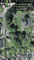
Wasn't quite sure on google view if that was a little park, or someone's garden. Turns out to belong to "The Old Vicarage", which is for sale and contains nobody to ask for permission :(
