Difference between revisions of "2014-01-20 34 -118"
From Geohashing
imported>Bravissimo594 m ([live] No parking allowed on Railroad Ave. Heading to the west side of the dry river.) |
imported>Bravissimo594 m ([live picture] Made it! [http://www.openstreetmap.org/?lat=34.40149301&lon=-118.53950382&zoom=16&layers=B000FTF @34.4015,-118.5395]) |
||
| Line 49: | Line 49: | ||
--> | --> | ||
<gallery perrow="5"> | <gallery perrow="5"> | ||
| + | |||
| + | Image:2014-01-20_34_-118_17-24-50-491.jpg | Made it! [http://www.openstreetmap.org/?lat=34.40149301&lon=-118.53950382&zoom=16&layers=B000FTF @34.4015,-118.5395] | ||
</gallery> | </gallery> | ||
Revision as of 01:24, 21 January 2014
| Mon 20 Jan 2014 in 34,-118: 34.4015294, -118.5395423 geohashing.info google osm bing/os kml crox |
Location
In the dry South Fork River (wash) off of Railroad Ave. in Santa Clarita.
Participants
Plans
- Boppy5 and I intend to get to this Los Angeles hash point at 4:00pm on Monday. I am not sure what the parking availability is nearby on Railroad Avenue, so there may be a delay related to that. Bravissimo594 (talk)
- If parking is not available on Railroad Avenue then we will try to get to the point by parking at the cul-de-sac of Faisan Court, on the west side of the river (and west of large power lines). Bravissimo594 (talk) 14:01, 19 January 2014 (EST)
Expedition
- It looks like it will be closer to 4:30 or 4:45. -- Bravissimo594 (talk) 18:29, 20 January 2014 (EST)
- Leaving Pasadena. -- Bravissimo594 (talk) @34.1523,-118.1254 19:29, 20 January 2014 (EST)
- No parking allowed on Railroad Ave. Heading to the west side of the dry river. -- Bravissimo594 (talk) @34.4132,-118.5593 20:11, 20 January 2014 (EST)
Tracklog
Photos
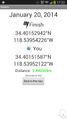
Made it! @34.4015,-118.5395

Achievements