Difference between revisions of "2014-01-22 46 -120"
From Geohashing
imported>CBos (→Expedition Map) |
imported>GeorgDerReisende (map and categories added) |
||
| Line 1: | Line 1: | ||
| + | {{meetup graticule | ||
| + | | lat=46 | ||
| + | | lon=-120 | ||
| + | | date=2014-01-22 | ||
| + | }} | ||
| + | |||
| + | |||
| + | __NOTOC__ | ||
== Location == | == Location == | ||
| Line 30: | Line 38: | ||
== Achievements == | == Achievements == | ||
| + | |||
| + | [[Category:Expeditions]] | ||
| + | [[Category:Expeditions with photos]] | ||
| + | |||
| + | [[Category:Coordinates not reached]] | ||
Revision as of 21:32, 23 January 2014
| Wed 22 Jan 2014 in 46,-120: 46.5097610, -120.4544739 geohashing.info google osm bing/os kml crox |
Location
- South of Union Gap along I-82
- Thorp Road/Yakima Valley Highway
- On the bank of the Yakima River
Participants
- Cbos
- Guest
Plans
Meet up after work and try to reach hash before it's too dark to see anything.
Expedition
- Met up at my house
- Dithered about trying to figure how to make an Iphone show Lat/Long
- Reached park-and-ride near hash around astronomical twilight
- Guest (owner of said Iphone) got cold feet and refused to walk the 50 meters down a slope to the sight of the hash
- Abandoned expedition despite hash being in sight
- Went home frustarted
Will attempt more hashes in the future!
Expedition Map
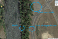
So close!
